Ban Phue District
Ban Phue (Thai: บ้านผือ, pronounced [bâːn pʰɯ̌ː]) is a district (amphoe) in the northwestern part of Udon Thani Province, northeastern Thailand.
Ban Phue บ้านผือ | |
|---|---|
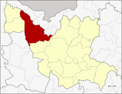 District location in Udon Thani Province | |
| Coordinates: 17°41′15″N 102°28′22″E | |
| Country | Thailand |
| Province | Udon Thani |
| Seat | Ban Phue |
| Area | |
| • Total | 991.2 km2 (382.7 sq mi) |
| Population (2008) | |
| • Total | 107,965 |
| • Density | 108.2/km2 (280/sq mi) |
| Time zone | UTC+7 (ICT) |
| Postal code | 41190 |
| Geocode | 4117 |
Geography
Neighboring districts are (from the north clockwise) Sangkhom, Pho Tak, Tha Bo, and Sakhrai of Nong Khai Province, Phen, Mueang Udon Thani, and Kut Chap of Udon Thani Province, Suwannakhuha of Nong Bua Lamphu Province, and Nam Som and Na Yung of Udon Thani.
Located within the district is the Phu Phra Bat Historical Park and the Phu Phra Bat Buabok Forest Park.
Administration
The district is divided into 13 sub-districts (tambons), which are further divided into 165 villages (mubans). Ban Phue is a sub-district municipality (thesaban tambon) which covers parts of tambon Ban Phue. There are a further 13 tambon administrative organizations (TAO).
| No. | Name | Thai | Villages | Pop.[1] |
|---|---|---|---|---|
| 1. | Ban Phue | บ้านผือ | 14 | 13,286 |
| 2. | Hai Sok | หายโศก | 17 | 10,874 |
| 3. | Khuea Nam | เขือน้ำ | 14 | 9,038 |
| 4. | Kham Bong | คำบง | 11 | 6,838 |
| 5. | Non Thong | โนนทอง | 11 | 10,562 |
| 6. | Khao San | ข้าวสาร | 14 | 5,746 |
| 7. | Champa Mong | จำปาโมง | 17 | 10,540 |
| 8. | Klang Yai | กลางใหญ่ | 13 | 8,805 |
| 9. | Mueang Phan | เมืองพาน | 16 | 8,521 |
| 10. | Kham Duang | คำด้วง | 11 | 6,569 |
| 11. | Nong Hua Khu | หนองหัวคู | 11 | 7,233 |
| 12. | Ban Kho | บ้านค้อ | 6 | 3,146 |
| 13. | Nong Waeng | หนองแวง | 10 | 6,807 |
References
- "Population statistics 2008". Department of Provincial Administration. Archived from the original on 2009-08-20.
External links
- amphoe.com (Thai)