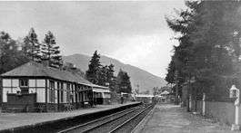
Balquhidder railway station
Balquhidder was a railway station around two miles south of Lochearnhead, Stirling (district). It was where the Callander and Oban Railway was joined by the Comrie, St Fillans & Lochearnhead Railway from Crieff.
| Balquhidder | |
|---|---|
 Balquhidder railway station in 1961 | |
| Location | |
| Place | Lochearnhead |
| Area | Stirling (district) |
| Coordinates | 56.35919°N 4.30978°W |
| Operations | |
| Original company | Callander and Oban Railway |
| Pre-grouping | Callander and Oban Railway operated by Caledonian Railway |
| Platforms | 3 |
| History | |
| 1 June 1870 | Opened as Lochearnhead[1] |
| 1 July 1904 | Renamed as Balquhidder[1] |
| 18 December 1904 | Station relocated south of original site |
| 28 September 1965 | Effective closure date |
| 1 November 1965 | Official closure date[1] |
| Disused railway stations in the United Kingdom | |
| Closed railway stations in Britain A B C D–F G H–J K–L M–O P–R S T–V W–Z | |
History
Opening and development
When opened as part of the Callander and Oban Railway on 1 June 1870,[1] Balquhidder station was called Lochearnhead. The station was laid out with two platforms, one on either side of a crossing loop. There were sidings on the east side of the station. The station was renamed as Balquhidder on 1 July 1904.[1]
Balquhidder station was relocated slightly further south on 18 December 1904 in preparation for it becoming a junction with the Comrie, St Fillans & Lochearnhead Railway. Upon the opening of the junction on 1 May 1905, the station boasted two signal boxes and an engine shed.
Closure
When the line to Crieff closed on 1 October 1951, the station ceased to be a junction.
The crossing loop was taken out of use on 21 March 1965.
This station was closed with the Callander and Oban line on 28 September 1965, six weeks before the scheduled closure on 1 November 1965 due to a landslide in Glen Ogle.[1]
Routes
| Preceding station | Historical railways | Following station | ||
|---|---|---|---|---|
| Kingshouse | Callander and Oban Railway Operated by the Caledonian Railway |
Glenoglehead | ||
| Terminus | Caledonian Railway Lochearnhead, St Fillans and Comrie Railway |
Lochearnhead | ||
Current status
The site is now a holiday park with log cabins, caravans, camping etc. Recently the station steps were repainted and repairs were undertaken to the crumbling wall of the remains of the waiting room. The pedestrian tunnel can still be accessed though is blocked half way through. Across the road, the old post office is now the site of the Golden Larches Restaurant.
References
Notes
- Butt (1995)
Sources
- Butt, R. V. J. (1995). The Directory of Railway Stations: details every public and private passenger station, halt, platform and stopping place, past and present (1st ed.). Sparkford: Patrick Stephens Ltd. ISBN 978-1-85260-508-7. OCLC 60251199.
- Jowett, Alan (March 1989). Jowett's Railway Atlas of Great Britain and Ireland: From Pre-Grouping to the Present Day (1st ed.). Sparkford: Patrick Stephens Ltd. ISBN 978-1-85260-086-0. OCLC 22311137.
- Jowett, Alan (2000). Jowett's Nationalised Railway Atlas (1st ed.). Penryn, Cornwall: Atlantic Transport Publishers. ISBN 978-0-906899-99-1. OCLC 228266687.