Baker, Oklahoma
Baker is a small rural unincorporated community in northeastern Texas County, Oklahoma, United States, ¼ mile north of U.S. Route 64. Tyrone lies six miles to the north-northwest on US Route 54 and Turpin lies eight miles to the east at the intersection of Route 64 and US Route 83 in adjacent Beaver County.[2]
Baker | |
|---|---|
 Baker Location within the state of Oklahoma  Baker Baker (the United States) | |
| Coordinates: 36°52′10″N 101°01′05″W[1] | |
| Country | United States |
| State | Oklahoma |
| County | Texas |
| Elevation | 2,848 ft (868 m) |
| Time zone | UTC-6 (Central (CST)) |
| • Summer (DST) | UTC-5 (CDT) |
| ZIP codes | 73950 |
Originally named Bakerburg, the post office opened June 5, 1931. The name was changed to Baker August 15, 1953. The community is said to have been named for Rueben F. Baker.[3]
NRHP Sites
Both the Baker Woodframe Elevator and the separate Baker Woodframe Grain Elevator are NRHP-listed.
gollark: Correction: R. Danny sets up a background task for each reminder due soon™, and also has a loop thing for longer running reminders which does what I said.
gollark: ++about
gollark: I did. It was just bad.
gollark: Typescript.
gollark: Anyway, the RDanny algorithm isn't horribly complex, it just finds the nearest one and waits for that. It's just annoying and edgecasey.
References
- U.S. Geological Survey Geographic Names Information System: Baker, Oklahoma
- Oklahoma Atlas & Gazeteer, DeLorme, 1st ed., 1998, p. 16 ISBN 0899332838
- Shirk, George H., Oklahoma Place Names, Norman: University of Oklahoma Press, 1987, p. 16 ISBN 0-8061-2028-2
Municipalities and communities of Texas County, Oklahoma, United States | ||
|---|---|---|
| Cities | 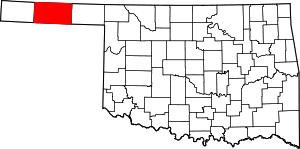 Texas County map | |
| Towns | ||
| Unincorporated communities | ||
This article is issued from Wikipedia. The text is licensed under Creative Commons - Attribution - Sharealike. Additional terms may apply for the media files.