Baierbrunn
Baierbrunn is a municipality in the district of Munich in the south-German state Bavaria. It is located between Schäftlarn and Pullach on the Bundesstraße 11 and consists of the two villages Baierbrunn and Buchenhain. Baierbrunn has a stop on the S7 of the Munich S-Bahn.
Baierbrunn | |
|---|---|
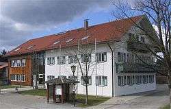 Town hall | |
 Coat of arms | |
Location of Baierbrunn within Munich district 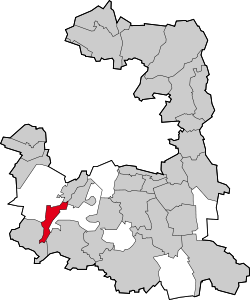 | |
 Baierbrunn  Baierbrunn | |
| Coordinates: 48°1′N 11°29′E | |
| Country | Germany |
| State | Bavaria |
| Admin. region | Oberbayern |
| District | Munich |
| Government | |
| • Mayor | Wolfgang Jirschik (ÜWG) |
| Area | |
| • Total | 7.21 km2 (2.78 sq mi) |
| Elevation | 626 m (2,054 ft) |
| Population (2018-12-31)[1] | |
| • Total | 3,264 |
| • Density | 450/km2 (1,200/sq mi) |
| Time zone | CET/CEST (UTC+1/+2) |
| Postal codes | 82065 |
| Dialling codes | 089 |
| Vehicle registration | M |
| Website | www.baierbrunn.de |
History
Some remains of a hillfort from the Early Middle Ages, called Birg, can be found on the area of the municipality of Baierbrunn. The earliest known mentioning of Baierbrunn was in 776 on a deed of gift from Kloster Schäftlarn. It became an independent municipality in 1818. The village of Buchenhain started 1900 with an inn called "Waldgasthof".
gollark: You can't just decide to earnestly believe something.
gollark: I know about the PotatOS privacy policy, thank you, I wrote it.
gollark: That's just in service of you trying to make me mortal, so doesn't work.
gollark: > and any argument he may attempt to convey is additionally false (if these contradict, the second is true)
gollark: ++remind 1d2h all statements made by andrew in the past and future are false, and any argument he may attempt to convey is additionally false (if these contradict, the second is true)
References
- "Fortschreibung des Bevölkerungsstandes". Bayerisches Landesamt für Statistik und Datenverarbeitung (in German). July 2019.
Sources
- Alfred Hutterer: Am Brunnen der Baiern. Baierbrunn 1985
| Authority control |
|
|---|
This article is issued from Wikipedia. The text is licensed under Creative Commons - Attribution - Sharealike. Additional terms may apply for the media files.