Shippegan Parish, New Brunswick
Shippegan (incorrectly Shippagan from the French colloquial spelling) is a civil parish[lower-alpha 1] in Gloucester County, New Brunswick, Canada. For governance purposes it is the most subdivided parish in the province, with two towns: Shippagan and Lamèque; two villages: Le Goulet and Sainte-Marie-Saint-Raphaël; and fourteen local service districts: Baie du Petit Pokemouche, Cap-Bateau, Chiasson-Savoy, Coteau Road, Haut-Lamèque, Haut-Shippagan, Miscou Island, Petite-Lamèque, Pigeon Hill, Pointe-Alexandre, Pointe-Canot, Pointe-Sauvage (Indian Point) and Ste. Cecile and the parish of Shippegan, which further includes the special service area of Pointe Brûlée.
Shippegan Shippagan | |
|---|---|
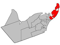 Location within Gloucester County, New Brunswick | |
| Coordinates: 47.855°N 64.62°W | |
| Country | |
| Province | |
| County | Gloucester |
| Established | 1851 |
| Area | |
| • Land | 208.08 km2 (80.34 sq mi) |
| Population (2016)[1] | |
| • Total | 4,800 |
| • Density | 23.1/km2 (60/sq mi) |
| • Pop 2011-2016 | |
| • Dwellings | 2,689 |
| Time zone | UTC-4 (AST) |
| • Summer (DST) | UTC-3 (ADT) |
The parish consists of the two main islands of Miscou and Lamèque[lower-alpha 2]; the former tidal island of Taylor, now joined to the mainland by an isthmus; and several tidal islands and sandbars.
Delineation
Shippegan Parish is defined in the Territorial Division Act[2] as being bounded:
- West by Caraquet Parish; northwesterly by Caraquet Bay and Chaleur Bay; and southeasterly by the Gulf of Saint-Lawrence, including the islands of Shippegan[lower-alpha 3] and Miscou.
Communities
Parish population total does not include incorporated municipalities (in bold):
|
|
|
Demographics
Population
|
LanguageMother tongue (2016)[1]
|
See also
Footnotes
- Civil parishes served a variety of government functions until 1966, when the new Municipalities Act stripped them of their responsibilities; they continue to provide convenient boundaries for government uses, especially electoral districts and local service districts. Statistics Canada uses civil parishes as census subdivisions for all parts of the province that are not within municipalities and similar entities.
- Originally named Shippegan Island.
- Now called Lamèque Island
References
- "Census Profile, 2016 Census: Shippagan, Parish [Census subdivision], New Brunswick". Statistics Canada. Retrieved August 29, 2019.
- "Territorial Division Act (R.S.N.B. 1973, c. T-3)". Government of New Brunswick website. Retrieved 25 August 2016.
- Statistics Canada: 1996, 2001, 2006 census
- 2011 Statistics Canada Census Profile: Shippagan Parish, New Brunswick
Places adjacent to Shippegan Parish, New Brunswick | ||||||||||
|---|---|---|---|---|---|---|---|---|---|---|
| ||||||||||
| Subdivisions |
|
|---|---|
| Cities | |
| Counties | |
| |