Baião, Portugal
Baião (Portuguese pronunciation: [baˈjɐ̃w] (![]()
Baião | |
|---|---|
.jpg) | |
 Flag  Coat of arms | |
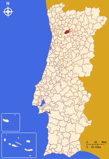 | |
| Coordinates: 41°10′N 8°02′W | |
| Country | |
| Region | Norte |
| Intermunic. comm. | Tâmega e Sousa |
| District | Porto |
| Parishes | 14 |
| Government | |
| • President | Paulo Pereira (PS) |
| Area | |
| • Total | 174.53 km2 (67.39 sq mi) |
| Population (2011) | |
| • Total | 20,522 |
| • Density | 120/km2 (300/sq mi) |
| Time zone | UTC±00:00 (WET) |
| • Summer (DST) | UTC+01:00 (WEST) |
| Website | http://www.cm-baião.pt |
Baião received a charter from Manuel I on 1 September 1513.
The present Mayor is Paulo Pereira, elected from the Socialist Party. The municipal holiday is August 24.
Parishes
Administratively, the municipality is divided into 14 civil parishes (freguesias):[3]
- Ancede e Ribadouro (town of Ancede)
- Baião (Santa Leocádia) e Mesquinhata
- Campelo e Ovil (town of Baião)
- Frende
- Gestaçô
- Gove
- Grilo
- Loivos da Ribeira e Tresouras
- Loivos do Monte
- Santa Cruz do Douro e São Tomé de Covelas
- Santa Marinha do Zêzere (town)
- Teixeira e Teixeiró
- Valadares
- Viariz
gollark: Long—Kebab—Pascal—Case
gollark: Pascal|Pipe|Case
gollark: SCREAMING-KEBAB-CASE
gollark: It lets you use your preferred style as long as it isn't wrong like PascalCase.
gollark: They should just convert all to title case like I am.
References
- Instituto Nacional de Estatística Archived November 15, 2016, at the Wayback Machine
- "Áreas das freguesias, concelhos, distritos e país". Archived from the original on 2018-11-05. Retrieved 2018-11-05.
- Diário da República. "Law nr. 11-A/2013, page 552 21" (pdf) (in Portuguese). Retrieved 17 July 2014.
This article is issued from Wikipedia. The text is licensed under Creative Commons - Attribution - Sharealike. Additional terms may apply for the media files.