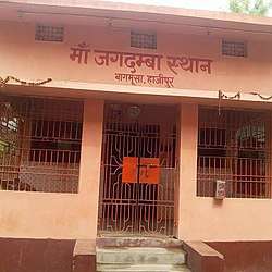
Bagmusha
Bagmusha is a village of Hajipur Block and Tirhut Division of Bihar.Bagmusha is very nearest of Hajipur junction and NH 19.
Bagmusha (Hajipur) | |
|---|---|
 Chhoti Jagdmba Asthan Bagmusha Hajipur | |
 Bagmusha (Hajipur) Location in Bihar, India | |
| Coordinates: 25.68°N 85.22°E | |
| Country | |
| State | Bihar |
| Division | Tirhut |
| District | Vaishali |
| Block | Hajipur |
| Government | |
| • Type | Nagar Parishad |
| • Body | Hajipur Town council Ward no.-4 |
| Elevation | 46 m (151 ft) |
| Population (2011) | |
| • Total | 2,510 |
| Languages | |
| • Spoken | Hindi, English, Bajjika |
| Time zone | UTC+5:30 (IST) |
| PIN | 844101 |
| Telephone code | 91- 6224- XX XX XX |
| Vehicle registration | BR-31 |
| Sex ratio | 1.0807 ♂/♀ |
| Lok Sabha constituency | Hajipur |
| Vidhan Sabha constituency | Hajipur |
| Website | vaishali |
Demographics
As per 2011 census Bagmusha has a population of 2510, of which males were 1352 and females were 1158. The literacy rate was 79.26 per cent, higher than the national average of 74.04%: male literacy is 84.78%, and female literacy is 72.93%. In Hajipur, 16% of the population is under 6 years of age. The sex ratio of 873 females per 1,000 males was lower than the national average of 944.[1]
Transports
- Rail link
Hajipur junction railway station only 100 meters distance from Bagmusha.
Hajipur railway station is the headquarters of East Central Railway Zone. Three rail lines connect it to Muzaffarpur, Chhapra, and Barauni. Important trains like Guwahati Rajdhani Express (2235/2236), Vaishali Express (2553/2554), Bihar Sampark Kranti Superfast Express (2565/2566), Garib Rath Express (2203/2204), Swatantrata Senani Superfast Express (2561/2562), Sabarmati Express, Lohit Express, Lichhavi Express (4005/4006) and all other trains passing through this route have stoppages here.
- Air
Patna Airport - 13.2 miles (21.2 km). Patna airport is well connected through road. Buses, taxis, auto available 24*7.
- Roads
Hajipur is connected to other parts of India through national and state highways. The major highways are:
- National Highway 19 (NH 19) touches the city and connects it to Chhapra which further joins Ghazipur city in U.P. NH 19 starts from Patna and is connected further with Gaya and BodhGaya through state highway.
- National Highway 77 (NH 77) connects Hajipur to Sonbarsa (Nepal border) via Muzaffarpur and Sitamarhi.
- National Highway 103 (NH 103) Starts from Hajipur and joins NH 28A at Musri Gharari (Samastipur) via Jandaha.
- State Highway 74 (SH-74) connects Hajipur to Lalganj, Vaishali.
- State highway 49 (SH-49) connects Hajipur to Mahuaa, Tajpur, Samastipur.
- State highway 93 (SH-93) connects Hajipur to Mahnar, Mohddinagar.
Bus services are available from Hajipur to Patna (10 km), Muzaffarpur (52.5 km), Kumar Bajitpur (40 km) Chhapra (60 km), Siwan (123 km), Samastipur (65 km), Motihari (136 km), Bettiah etc.
Media
Hindi and English newspapers are easily available in the city, including Dainik Jagran, Hindustan, Prabhat Khabar, The Telegraph (Calcutta) and The Times of India, Dainik Bhaskar.
TV programming is provided by regional news channels like Sahara Samay, ETV Bihar and Jharkhand. There are several news programmes broadcast by local cable operators in city areas.
Hajipur has the following FM radio stations: Radio Mirchi Patna 98.3 and Vividh Bharati (All India Radio) is broadcast on 100.8 FM.
Education
- Government Primary school Bagmusha
- Gyan Ganga Public School
- Laliteshana I.T.I College
- Coaching
- Gyan Guru Coaching
- Electrol Technical Coaching
Direction board
See also
- Lal Keshwar Shiv Temple
- Vidyapati Nagar
- Kancha
- Kacchi Dargah-Bidupur Bridge
- Shahpur Patori railway station
- Patna-Sonepur-Hajipur Section
- SH 93
- G.A.Inter School Hajipur
- Khagaria Junction railway station
- Mohiuddinnagar railway station
- Hajipur-Muzaffarpur-Samastipur-Barauni Section
- Akshaywat Rai Nagar Railway Station
- Chak Sikandar Railway Station
References
- 168 Hajipur census2011.co.in