BR-285
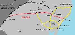
BR-285 is an east-west Brazilian federal highway that starts in Araranguá, Santa Catarina, and crosses the Gaucho range and highlands. It stretches approximately 674.5 km, passing through cities such as Vacaria, Lagoa Vermelha, Passo Fundo, Carazinho, Ijuí e São Luiz Gonzaga, and ends in São Borja, Rio Grande do Sul, on the border of Argentina.
| |
|---|---|
 | |
| Route information | |
| Length | 674.50 km[1] (419.11 mi) |
| Major junctions | |
| East end | Araranguá, Santa Catarina |
BR-470 in Lagoa Vermelha BR-158 in Panambi | |
| West end | São Borja, Rio Grande do Sul |
| Highway system | |
| Highways in Brazil | |

Gallery
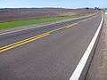 BR-285 in Lagoa Vermelha.
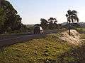 BR-285 in Panambi, in Northwestern Rio Grande do Sul.
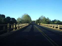 Bridge on the Caxambu River on BR-285 in Panambi.
gollark: Why do you have that much? More than two Chrome tabs?
gollark: GPU and CPU, apparently.
gollark: Folding@Home's client isn't actually open source, and who knows if they're just executing arbitrary code from people through it?
gollark: Personally I would be more worried about the security of this distributed computing stuff.
gollark: <@157607369331834880> It's probably not a *Bitcoin* miner, since mining for Bitcoin can only be done competitively on ASICs at this point.
References
- "BR-285 length between major junctions". Ministério dos Transportes do Brasil. Archived from the original on November 22, 2012. Retrieved August 24, 2014.
| Rodovias radiais | |
|---|---|
| Rodovias longitudinais | |
| Rodovias transversais |
|
| Rodovias diagonais | |
| Rodovias de ligação |
|
This article is issued from Wikipedia. The text is licensed under Creative Commons - Attribution - Sharealike. Additional terms may apply for the media files.