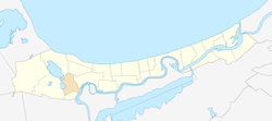
Bāžciems
Bāžciems is a residential area and neighbourhood of the city Jūrmala, Latvia.
Bāžciems | |
|---|---|
 Location in Jūrmala | |
 Bāžciems Location in Latvia | |
| Coordinates: 56°56′N 23°36′E | |
| Country | |
| City | Jūrmala |
| Area | |
| • Total | 3.6 km2 (1.4 sq mi) |
| Elevation | 3 m (10 ft) |
| Population (2008)[1] | |
| • Total | 9 |
| • Density | 2.5/km2 (6/sq mi) |
History
The Bāžciems or Bāžnieki (German: Bahseneck), belonging to the Duke of Courland, Sloka manor, formed the boundary of the Slokas town, marked by the Vecslocenes River with mills. During the Polish-Swedish War in 1605-1608 Swedes erected fortifications here. In the period of Kurzeme's economic prosperity, the Duke Jacob Kettler wanted to create a rival export port in Riga at Sloka, where glass factories and copper smelting were established. He ordered the construction of a canal linking the Slokas port to the Lielupe with the Baltic Sea through the present River Vecslocene and the Slokas lake .
In 1783, Slokas Manor was separated from the Sloka region from the Duchy of Courland and Zemgale and added to the Russian Empire. The village in 1795 had 159 inhabitants - 82 men and 77 women.[2]
In 1925, the village was added to the town of Slokas. Slokas together with Bačciems was included in the city of Jurmala in 1959.
References
- Jūrmalas pilsētas teritorijas plānojums
- (in Latvian) P. Belte. Rīgas Jūrmalas, Slokas un Ķemeru pilsētas ar apkārtni. Vēsturisks apskats ar 204 ilustrācijām. 1935. 50 lpp.