Aucara District
Aucará District is one of twenty-one districts of the Lucanas Province in Peru.[1]
Aucará | |
|---|---|
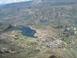 The lake Quchapampa and the village of Aucará | |
| Country | |
| Region | Ayacucho |
| Province | Lucanas |
| Capital | Aucará |
| Government | |
| • Mayor | Ismael Tito Ccoyllo |
| Area | |
| • Total | 903.51 km2 (348.85 sq mi) |
| Elevation | 3,220 m (10,560 ft) |
| Population (2005 census) | |
| • Total | 2,744 |
| • Density | 3.0/km2 (7.9/sq mi) |
| Time zone | UTC-5 (PET) |
| UBIGEO | 050602 |
Geography
One of the highest mountains of the district is Kunturillu at approximately 4,600 m (15,100 ft). Other mountains are listed below:[2]
- Aqu Q'asa
- Aya Qullqa
- Hatun Sayri
- Illa Q'asa
- Inka Phaqcha
- Kiru Chuku
- Llama Wasi
- Machu P'unqu
- Minaschayuq
- Misa Q'asa
- Misa Urqu
- Muqu Wasi
- Muyu Muyu
- Pata Wasi
- Puka Phiruru
- Puka Qullpa
- Puma Ranra
- Puywan
- Phiruruyuq
- Qillqay Saywa
- Qurip Sunqun
- Quriwayrachina
- Q'illu Sura
- Ranra Urqu
- Sayaq Mach'ay
- Saywa
- Saywa Pata
- Sura Q'asa
- Ranra Urqu
- Ukru Kancha
- Waña Pampa
- Waqutu
- Waraqu
- Yana Qaqa
- Yana Urqu
Ethnic groups
The people in the district are mainly indigenous citizens of Quechua descent. Quechua is the language which the majority of the population (52.65%) learnt to speak in childhood, 47.04% of the residents started speaking using the Spanish language (2007 Peru Census).[3]
gollark: osmarkshypotheticalchatprotocol™ is much better.
gollark: It also probably serves as load balancing since the computers of this time were worse.
gollark: But as long as one person did the network could work across them.
gollark: Most people did not have access to intercontinental or really long distance links IIRC.
gollark: The networks of the time just wouldn't make it practical to have everyone connect to one server somewhere like we can now.
See also
References
- (in Spanish) Instituto Nacional de Estadística e Informática. Banco de Información Distrital Archived April 23, 2008, at the Wayback Machine. Retrieved April 11, 2008.
- escale.minedu.gob.pe - UGEL maps of the Lucanas Province 2, Ayacucho Region
- inei.gob.pe Archived January 27, 2013, at the Wayback Machine INEI, Peru, Censos Nacionales 2007, Frequencias: Preguntas de Población: Idioma o lengua con el que aprendió hablar (in Spanish)
| |
|---|---|
| Cangallo | |
| Huamanga | |
| Huanca Sancos | |
| Huanta | |
| La Mar | |
| Lucanas | |
| Parinacochas | |
| Paucar del Sara Sara | |
| Sucre | |
| Víctor Fajardo | |
| Vilcas Huamán | |
This article is issued from Wikipedia. The text is licensed under Creative Commons - Attribution - Sharealike. Additional terms may apply for the media files.