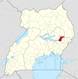
Atutur Town
Atutur | |
|---|---|
 Atutur Location in Uganda | |
| Coordinates: 01°19′25″N 33°53′18″E | |
| Country | |
| Region | Eastern Uganda |
| Sub-region | Teso sub-region |
| District | Kumi District |
| Elevation | 3,540 ft (1,080 m) |
Atutur is a town in the Eastern Region of Uganda.
Location
The town lies on the Tirinyi–Pallisa–Kamonkoli–Kumi Road, in Atutur Parish, Atutur sub-county, Kumi District, approximately 22 kilometres (14 mi) southeast of Kumi Town, where the district headquarters are located.[1] Atutur is located 48 kilometres (30 mi) northwest of Mbale, the nearest large city.[2] The coordinates of Atutur Town are: 01°19'25.0"N, 33°53'18.0"E (Latitude:1.323605; Longitude:33.888341).[3]
Overview
Atutur General Hospital sits in Atutur sub-county, on the Tororo–Mbale–Soroti Road, about 17 kilometres (11 mi) northeast of Atutur Town.[4]
gollark: But why would they share resources unless… *they're the same*?
gollark: Lemmmy is Yemmel. This much is obvious.
gollark: It was answering a question! Somewhat late, admittedly.
gollark: <@290217153293189120> codersnet is a COOLER Minecraft server.
gollark: Kill AstroMan. He has violated the Trademark Covenant.
References
- GFC (13 May 2016). "Distance between Atutur, Eastern Region, Uganda and Kumi, Eastern Region, Uganda". Globefeed.com (GFC). Retrieved 13 May 2016.
- GFC (13 May 2016). "Distance between Mbale, Eastern Region, Uganda and Atutur, Eastern Region, Uganda". Globefeed.com (GFC). Retrieved 13 May 2016.
- Google (13 May 2016). "Location of Atutur Town, Kumi District, Uganda" (Map). Google Maps. Google. Retrieved 13 May 2016.
- GFC (13 May 2016). "Distance between Atutur, Eastern Region, Uganda and Atutur Hospital, Kumi, Eastern Region, Uganda". Globefeed.com (GFC). Retrieved 13 May 2016.
External links
This article is issued from Wikipedia. The text is licensed under Creative Commons - Attribution - Sharealike. Additional terms may apply for the media files.
