Atmakur, Kurnool district
Atmakur is a town in the Kurnool district of Andhra Pradesh, India. It's located at a distance of 50 kms from Nandyal, 70 kms from Kurnool and 110 kms from Srisailam. [2]
Atmakur | |
|---|---|
[municipality] | |
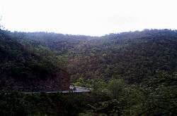 Nallamalla hills near Atmakur | |
.svg.png) Atmakur Location in Andhra Pradesh, India | |
| Coordinates: 15.87791°N 78.58842°E | |
| Country | India |
| State | Andhra Pradesh |
| District | Kurnool |
| Talukas | Atmakur |
| Area | |
| • Total | 43.72 km2 (16.88 sq mi) |
| Population (2011)[2] | |
| • Total | 45,703 |
| • Density | 1,000/km2 (2,700/sq mi) |
| Languages | |
| • Official | Telugu |
| Time zone | UTC+5:30 (IST) |
| PIN | 518422 |
| Telephone code | +91–8517 |
| Vehicle registration | AP |
| Website | Atmakur municipality |
References
- "Municipalities, Municipal Corporations & UDAs" (PDF). Directorate of Town and Country Planning. Government of Andhra Pradesh. Archived from the original (PDF) on 28 January 2016. Retrieved 29 January 2016.
- "Census 2011". The Registrar General & Census Commissioner, India. Retrieved 7 October 2014.
This article is issued from Wikipedia. The text is licensed under Creative Commons - Attribution - Sharealike. Additional terms may apply for the media files.