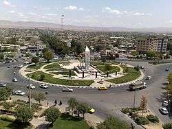
Quchan
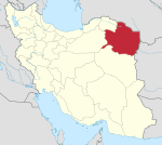
Quchan (Persian: قوچان Qučān pronounced [quˈtʃɑːn, ɢoˈtʃɒːn]; also Romanized as Qūchān and Quçan; also known as Gochan)[2] is a city and capital of Quchan County, in Razavi Khorasan Province, Iran. It is located due south of the border city of Ashgabat. At the 2006 census, its population was 96,953, in 25,066 families.[3]
Quchan | |
|---|---|
City | |
 | |
 Quchan | |
| Coordinates: 37°06′22″N 58°30′34″E | |
| Country | |
| Province | Razavi Khorasan |
| County | Quchan |
| Bakhsh | Central |
| Population (2016 Census) | |
| • Urban | 101,604 [1] |
| Time zone | UTC+3:30 (IRST) |
| • Summer (DST) | UTC+4:30 (IRDT) |
| Quchan at GEOnet Names Server | |
Population
In a 2006 census, Quchan's population was 96,953 consisting of mostly Kurds, Persians, and Turks .
Geography
Quchan is in the north-east of Iran in Razavi Khorasan Province at an elevation of 1,149 meters above sea level north of the Shah Jahan Mountains. It is located south of the border with Turkmenistan. Quchan is connected by road to Mashhad, 125 km southeast and Turkmenistan, 100 km north.
Quchan has suffered from many earthquakes, and the town was relocated about 10 km east of the original town in 1895 following its destruction in another earthquake.[4]
Economy
Grains and wine are among the district's produce.
Education
- Quchan University of Technology
- Islamic Azad University — Quchan Branch
Notable people
History
On 20 June 1747, Nader Shah was assassinated in Quchan. He was surprised in his sleep by Salah Bey, captain of the guards, and stabbed with a sword. Nader was able to kill two of the assassins before he died.
A devastating earthquake in 1893 killed 10,000 residents in Quchan. The US press reported on January 28, 1894, "The bodies of ten thousand victims of the awful disaster have already been recovered. Fifty thousand cattle were destroyed at the same time. The once important and beautiful city of twenty thousand people is now only a scene of death, desolation, and terror."
References
- https://www.amar.org.ir/english
- Quchan can be found at GEOnet Names Server, at this link, by opening the Advanced Search box, entering "-3080451" in the "Unique Feature Id" form, and clicking on "Search Database".
- "Census of the Islamic Republic of Iran, 1385 (2006)". Islamic Republic of Iran. Archived from the original (Excel) on 2011-11-11.
- Hollingsworth, J.; Jackson J.; Waler R.; Gheitanchi M.R.; Bolourchi M.J. (2006). "Strike-slip faulting, rotation, and along-strike elongation in the Kopeh Dagh mountains, NE Iran" (PDF). Geophysical Journal International. Royal Astronomical Society. 166: 1161–1177. doi:10.1111/j.1365-246x.2006.02983.x. Archived from the original (PDF) on 11 December 2013. Retrieved 18 August 2012.
- ^ Allen, Thomas Gaskell Jr; Sachtleben, William Lewis (1894). Across Asia on a Bicycle (1903 ed.). New York: The Century Co. p. 110.
- The website about Quchan city
See also
- The Story of the Daughters of Quchan, a 1998 political history by Afsaneh Najmabadi.
