Ashtabula River
The Ashtabula River[4] is a river located northeast of Cleveland in Ohio. The river flows into Lake Erie at the city of Ashtabula, Ohio. It is 40 miles (64 km) in length and drains 137 square miles (350 km2).
| Ashtabula River | |
|---|---|
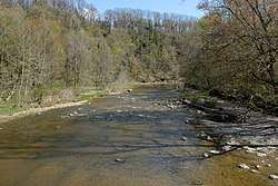 The Ashtabula River as viewed from the Riverview Covered Bridge | |
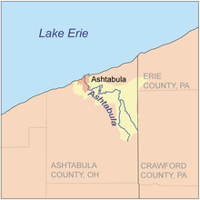 Map of the Ashtabula River and its watershed | |
| Location | |
| Country | United States of America |
| State | Ohio |
| County | Ashtabula County |
| Physical characteristics | |
| Source | |
| • location | Confluence of east and west branches in Monroe Township, Ashtabula County |
| • coordinates | 41°48′51″N 80°36′57″W[1] |
| • elevation | 850 feet (260 m)[2] |
| Mouth | |
• location | Lake Erie at Ashtabula, Ohio |
• coordinates | 41°54′36″N 80°47′55″W[1] |
• elevation | 571 feet (174 m)[1] |
| Length | 40 miles (64 km) |
| Basin size | 137 square miles (350 km2)[3] |
Name
Ashtabula derives from Lenape language ashte-pihële, 'always enough (fish) to go around, to be given away',[5] a contraction from apchi 'always'[6] + tepi 'enough' + hële (verb of motion).[7][8][9]
According to the Geographic Names Information System, the Ashtabula River has also been known as:[1]
- Ashtibula River
- Riviere Auscubalu
- Riviere Oscubolu
Watershed
On October 30, 2008 the river was designated a State Scenic River by the Director of the Ohio Department of Natural Resources.
Pollution
In 1985 the first two miles of the river was named an Area of Concern by the International Joint Commission, primarily because of Fields Brook, a tributary that had received discharges from 19 industries between the 1940s and 1970s. The cleanup was deemed complete in 2014.[10]
Tributaries
- Fields Brook
- Strong Brook
- Hubbard Run
- Ashtabula Creek
- West Branch Ashtabula River
- East Branch Ashtabula River
See also
- List of rivers of Ohio
- Ashtabula River railroad disaster (1876)
- Smolen–Gulf Bridge, a covered bridge across the river (2008–present)
- USS Ashtabula (AO-51)
References
- U.S. Geological Survey Geographic Names Information System: Ashtabula River
- United States Geological Survey. Pierpont quadrangle, Ohio. 1:24,000. 7.5 Minute Series. Washington D.C.: USGS, 1994.
- "Map of Ohio watersheds". Archived from the original on 2007-03-11.
- United States Geological Survey Hydrological Unit Code: 04-11-00-03-050
- Mahr, August C. (November 1959). "Practical Reasons for Algonkian Indian Stream and Place Names". Ohio Journal of Science. 59 (6): 365–375. ISSN 0030-0950. Retrieved 2016-08-03.
- "apchi". Lenape Talking Dictionary. Archived from the original on 2016-03-04. Retrieved 2016-09-01.
- "tèpihële". Lenape Talking Dictionary. Archived from the original on 2016-03-04. Retrieved 2016-09-01.
- "History Page - City of Ashtabula". Archived from the original on 2008-07-31.
- Rose, William Ganson (1950). Cleveland: The Making of a City. Kent, Ohio: Kent State University Press. p. 1065. ISBN 0873384288.
- Sheil, Bill (2014-09-07). "It's Official: Ashtabula River Is Clean After 25-year Project". WJW-TV. Retrieved 2014-09-08.