Arthur Passage
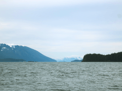
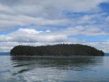
Arthur Passage is a marine waterway in British Columbia, Canada. It is part of the Inside Passage connecting Grenville Channel (at its southeast end) with Malacca Passage (at its northwest end)[1]. A significant feature is Hanmer Island, located in the middle of the north end of the passage[2].
| Arthur Passage | |
|---|---|
 Looking southward down Arthur Passage | |
| Coordinates | 54°01′45″N 130°14′21″W |
Name origin
Arthur Passage was named in 1867 by Captain Daniel Pender, RN, after the third governor of Vancouver Island, His Excellency Arthur E. Kennedy[3].
Ecology
The hyper-maritime forests surrounding Arthur Passage have extensive areas of wet, slow-growing forests of western redcedar and yellow-cedar. Macrofauna in the forest floor of Hanmer Island include Sowbugs, Millipedes, Centipedes, Potworms and Earthworms[4].
Hydrology
The Arthur Passage flood tide sets northerly and the ebb sets southerly, tidal currents attain 2.5 knots (4.6 km/h; 2.9 mph) near Hanmer Island[1].
History

In the morning of January 14, 1942, the American Troopship USAT David W. Branch, carrying 350 passengers, went aground on Hammer Island[5].
| Wikimedia Commons has media related to Arthur Passage. |
See also
- Inside Passage
- Chatham Sound
- Skeena river
References
- "Charts 3927, 3773, 3717, Arthur Passage". Sailing Directions, British Columbia Coast, (Northern Portion). II (Ninth Edition): 162–163. 1983.
- "Hanmer Island". BC Geographical Names.
- "Arthur Passage". BC Geographical Names.
- J.M. Kranabetter and A. BannerA. Selected biological and chemical properties offorest floors across bedrock types on the northcoast of British Columbia (Report). p. 971-981.CS1 maint: uses authors parameter (link) Kranabetter, J.M.; Banner, A. (February 2011). "Selected biological and chemical properties offorest floors across bedrock types on the northcoast of British Columbia" (PDF). Canadian Journal of Forest Research. 30 (6): 971–981. Archived from the original on 2011. Retrieved 2020-03-20.
- Roy, Dr. R. H. (1976). "[PDF] The Defence of Prince Rupert: An Eyewitness Account". The British Columbian Quarterly. Retrieved 2020-03-20.