Arros (river)
The Arros (Occitan: Arròs), is a right tributary of the Adour, in the Southwest of France.
| Arros | |
|---|---|
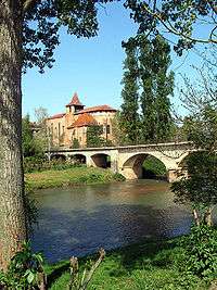 The Arros in Saint-Sever-de-Rustan | |
| Location | |
| Country | France |
| Physical characteristics | |
| Source | |
| • location | Baronnies of Pyrenees |
| Mouth | |
• location | Adour |
• coordinates | 43°39′44″N 0°1′41″W |
| Length | 131 km (81 mi) |
| Basin size | 947 km2 (366 sq mi) |
| Discharge | |
| • average | 9 m3/s (320 cu ft/s) |
| Basin features | |
| Progression | Adour→ Atlantic Ocean |
Name
The name Arros is based on the root Arr- 'stone' and the suffix -os.
Geography
The Arros rises in the Baronnies of Pyrenees, southeast of Bagnères-de-Bigorre, below the Signal de Bassia (1 921 m).
It flows north through a narrow valley defended by the castle of Mauvezin and the bastide of Tournay. It joins the Adour before it turn west, upstream from Riscle.
Départements and towns
Main tributaries
- (L) Esqueda, from Banios
- (L) Luz, from Lies
- (L) Arredou, in Tournay
- (L) Arret Daban or Arret Devant,
- (L) Arret Darré, in Gonez
- (R) Bouès, from Capvern
gollark: Presumably, it efficientizes™ it like that in some scenarios.
gollark: It takes an optional string, reads the length if it does exist, and invokes awful UB if it does not.
gollark: What a wondrous optimization.
gollark: No, just remove the bit connected to your ear.
gollark: Your ear has betrayed you; remove it.
This article is issued from Wikipedia. The text is licensed under Creative Commons - Attribution - Sharealike. Additional terms may apply for the media files.