Arrondissement of Marmande
The arrondissement of Marmande is an arrondissement of France in the Lot-et-Garonne department in the Nouvelle-Aquitaine region. It has 98 communes.[1] Its population is 83,647 (2016), and its area is 1,387.7 km2 (535.8 sq mi).[2]
Marmande | |
|---|---|
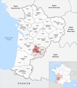 Location within the region Nouvelle-Aquitaine | |
| Country | France |
| Region | Nouvelle-Aquitaine |
| Department | Lot-et-Garonne |
| No. of communes | 98 |
| Subprefecture | Marmande |
| Area | |
| • Total | 1,387.7 km2 (535.8 sq mi) |
| Population (2016) | |
| • Total | 83,647 |
| • Density | 60/km2 (200/sq mi) |
| INSEE code | 472 |
Composition
The communes of the arrondissement of Marmande, and their INSEE codes, are:[1]
- Agmé (47002)
- Agnac (47003)
- Allemans-du-Dropt (47005)
- Antagnac (47010)
- Argenton (47013)
- Armillac (47014)
- Auriac-sur-Dropt (47018)
- Baleyssagues (47020)
- Beaupuy (47024)
- Birac-sur-Trec (47028)
- Bouglon (47034)
- Bourgougnague (47035)
- Brugnac (47042)
- Calonges (47046)
- Cambes (47047)
- Castelmoron-sur-Lot (47054)
- Castelnau-sur-Gupie (47056)
- Caubon-Saint-Sauveur (47059)
- Caumont-sur-Garonne (47061)
- Clairac (47065)
- Cocumont (47068)
- Coulx (47071)
- Couthures-sur-Garonne (47074)
- Duras (47086)
- Escassefort (47088)
- Esclottes (47089)
- Fauguerolles (47094)
- Fauillet (47095)
- Fourques-sur-Garonne (47101)
- Gaujac (47108)
- Gontaud-de-Nogaret (47110)
- Grateloup-Saint-Gayrand (47112)
- Grézet-Cavagnan (47114)
- Guérin (47115)
- Hautesvignes (47118)
- Jusix (47120)
- Labastide-Castel-Amouroux (47121)
- Labretonie (47122)
- Lachapelle (47126)
- Lafitte-sur-Lot (47127)
- Lagruère (47130)
- Lagupie (47131)
- Laparade (47135)
- Laperche (47136)
- Lauzun (47142)
- Lavergne (47144)
- Lévignac-de-Guyenne (47147)
- Longueville (47150)
- Loubès-Bernac (47151)
- Marcellus (47156)
- Marmande (47157)
- Le Mas-d'Agenais (47159)
- Mauvezin-sur-Gupie (47163)
- Meilhan-sur-Garonne (47165)
- Miramont-de-Guyenne (47168)
- Monteton (47187)
- Montignac-de-Lauzun (47188)
- Montignac-Toupinerie (47189)
- Montpouillan (47191)
- Moustier (47194)
- Pardaillan (47199)
- Peyrière (47204)
- Poussignac (47212)
- Puymiclan (47216)
- Puysserampion (47218)
- Romestaing (47224)
- Roumagne (47226)
- Ruffiac (47227)
- Saint-Astier (47229)
- Saint-Avit (47231)
- Saint-Barthélemy-d'Agenais (47232)
- Saint-Colomb-de-Lauzun (47235)
- Sainte-Bazeille (47233)
- Sainte-Colombe-de-Duras (47236)
- Sainte-Gemme-Martaillac (47244)
- Sainte-Marthe (47253)
- Saint-Géraud (47245)
- Saint-Jean-de-Duras (47247)
- Saint-Martin-Petit (47257)
- Saint-Pardoux-du-Breuil (47263)
- Saint-Pardoux-Isaac (47264)
- Saint-Pierre-sur-Dropt (47271)
- Saint-Sauveur-de-Meilhan (47277)
- Saint-Sernin (47278)
- Samazan (47285)
- La Sauvetat-du-Dropt (47290)
- Savignac-de-Duras (47294)
- Ségalas (47296)
- Sénestis (47298)
- Seyches (47301)
- Soumensac (47303)
- Taillebourg (47304)
- Tonneins (47310)
- Varès (47316)
- Verteuil-d'Agenais (47317)
- Villeneuve-de-Duras (47321)
- Villeton (47325)
- Virazeil (47326)
History
The arrondissement of Marmande was created in 1800.[3]
As a result of the reorganisation of the cantons of France which came into effect in 2015, the borders of the cantons are no longer related to the borders of the arrondissements. The cantons of the arrondissement of Marmande were, as of January 2015:[4]
- Bouglon
- Castelmoron-sur-Lot
- Duras
- Lauzun
- Marmande-Est
- Marmande-Ouest
- Le Mas-d'Agenais
- Meilhan-sur-Garonne
- Seyches
- Tonneins
gollark: I assumed they had been afflicted by the GPU shortage.
gollark: You *can*?
gollark: Also, observe: at last, rock/paper/scissors has been secured through "zero knowledge proofs" i.e. very simple applications of hash functions.
gollark: That's quite bad. Do NOT buy it for that.
gollark: Well, it hasn't obtained any new articles since December last year, and there have been more legal issues than usual.
References
- "Arrondissement de Marmande (472)". INSEE. Retrieved 2019-10-01.
- "Comparateur de territoire, géographie au 01/01/2019". INSEE. Retrieved 2019-10-01.
- Historique de Lot-et-Garonne
- "Populations légales 2012" (PDF). INSEE. December 2014. Retrieved 2019-10-22.
This article is issued from Wikipedia. The text is licensed under Creative Commons - Attribution - Sharealike. Additional terms may apply for the media files.