Arkansas Highway 396
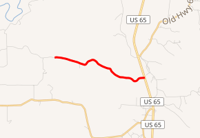
Arkansas Highway 396 (AR 396 or Hwy. 396) is a rural, 2.5-mile-long (4.0 km) state highway in Boone County. It splits west from U.S. Route 65 (U.S. 65) north of Burlington.
| ||||
|---|---|---|---|---|

| ||||
| Route information | ||||
| Maintained by ArDOT | ||||
| Length | 2.56 mi[1] (4.12 km) | |||
| Major junctions | ||||
| West end | Ursey Road near Burlington | |||
| East end | ||||
| Location | ||||
| Counties | Boone | |||
| Highway system | ||||
| ||||
Route description
AR 396 begins along Ursey Road, a rural highway in Long Creek Township. It heads east for 2.5 miles (4.0 km) through undulating hills of Boone County until it ends at U.S. 65 north of Burlington.[1]
Major intersections
The entire route is in Long Creek Township, Boone County.
| mi[1] | km | Destinations | Notes | ||
|---|---|---|---|---|---|
| 0.00 | 0.00 | Ursey Road | End state maintenance | ||
| 2.56 | 4.12 | ||||
| 1.000 mi = 1.609 km; 1.000 km = 0.621 mi | |||||
gollark: <@319753218592866315> What?
gollark: AutoBotRobot actually has to do a bunch of AST hackery to make asynchronousness work.
gollark: &sys exec await ctx.send("APIOID")
gollark: I don't know how.
gollark: This is not helpful.
References
- Route and Section Map (PDF) (Map). Boone County. Arkansas State Highway and Transportation Department. Retrieved May 13, 2011.
External links
This article is issued from Wikipedia. The text is licensed under Creative Commons - Attribution - Sharealike. Additional terms may apply for the media files.
