Arkansas Highway 363
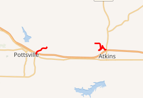
Arkansas Highway 363 is the name of two state highways in Pope County.[2]
| ||||
|---|---|---|---|---|

| ||||
| Route information | ||||
| Maintained by ArDOT | ||||
| Section 1 | ||||
| Length | 1.08 mi[1] (1.74 km) | |||
| South end | ||||
| North end | Phillips Road near Pottsville | |||
| Section 2 | ||||
| Length | 2.10 mi[1] (3.38 km) | |||
| East end | Local road outside Atkins | |||
| West end | ||||
| Location | ||||
| Counties | Pope | |||
| Highway system | ||||
| ||||
Section 1
Arkansas Highway 363 is a 1.0-mile-long (1.6 km) state highway in Pope County near Pottsville. The route runs north from U.S. Route 64 (US 64) and AR 247 across Interstate 40 (I-40) to terminate at Phillips Road.
The entire route is in Pottsville, Pope County.
| mi[1] | km | Destinations | Notes | ||
|---|---|---|---|---|---|
| 0.00 | 0.00 | Northern terminus of AR 247 | |||
| 0.08 | 0.13 | Exit 88 (I-40) | |||
| 1.08 | 1.74 | End state maintenance at Phillips Road | |||
| 1.000 mi = 1.609 km; 1.000 km = 0.621 mi | |||||
Section 2

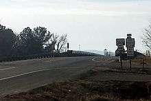
Highway 363 terminates at Highway 105 near I-40 in Atkins
Arkansas Highway 363 is a brief 2.1-mile-long (3.4 km) state highway in Pope County. It runs east into Atkins to terminate at AR 105 at the interchange with I-40 (exit 94).
The entire route is in Pope County.
| Location | mi[1] | km | Destinations | Notes | |
|---|---|---|---|---|---|
| | 0.00 | 0.00 | End state maintenance | ||
| Atkins | 2.10 | 3.38 | |||
| 1.000 mi = 1.609 km; 1.000 km = 0.621 mi | |||||
gollark: What? No, 35% or so can, at most.
gollark: I'm not sure what you would do about it without scaling down beef production a lot, which would make people unhappy, since I don't really know much about how farming works at large scales.
gollark: I have heard that it's quite polluting, yes.
gollark: I mean, if you want companies to be more environment, you can just tax emissions or something.
gollark: Would you prefer they make as little as possible at maximum cost?
References
- Route and Section Map (PDF) (Map). Pope County. Arkansas State Highway and Transportation Department. Retrieved August 25, 2011.
- Arkansas State Highway and Transportation Department. AHTD Pope County map Retrieved on April 3, 2010.
External links

This article is issued from Wikipedia. The text is licensed under Creative Commons - Attribution - Sharealike. Additional terms may apply for the media files.
