Arkansas Highway 237
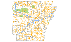
Arkansas Highway 237 (AR 237 and Hwy. 237) is a north–south state highway in Miller County. The route of 25.91 miles (41.70 km) runs north from Highway 160 in the extreme southwest corner of the state along the east side of Texarkana to US 67.[2]
| ||||
|---|---|---|---|---|
 | ||||
| Route information | ||||
| Maintained by ArDOT | ||||
| Length | 25.91 mi[1] (41.70 km) | |||
| Major junctions | ||||
| South end | ||||
| North end | ||||
| Location | ||||
| Counties | Miller | |||
| Highway system | ||||
| ||||
Route description
The route begins at Highway 160 about 2 miles (3.2 km) east of the Texas state line. The route runs north through the Sulphur River Wildlife Management Area to intersect I-49 south of Texarkana. Now entering the city, the route forms a brief concurrency with U.S. Route 71. The route now continues due north as Rondo Road to intersect Genoa Road and 9th Street. Now approaching the Texarkana Regional Airport, the route intersects Mandeville Road before terminating at Broad Street.
Major intersections
The entire route is in Miller County.
| Location | mi[1] | km | Destinations | Notes | |
|---|---|---|---|---|---|
| | 0.00 | 0.00 | south terminus | ||
| | 16.55 | 26.63 | interchange | ||
| Texarkana | 18.64 | 30.00 | |||
| 0.00 | 0.00 | ||||
| 2.79 | 4.49 | ||||
| 4.23 | 6.81 | ||||
| 7.19 | 11.57 | ||||
| 7.28 | 11.72 | ||||
| 1.000 mi = 1.609 km; 1.000 km = 0.621 mi | |||||
See also
References
- Planning and Research Division (2010). "Arkansas Road Log Database". Arkansas State Highway and Transportation Department. Archived from the original (Database) on 23 June 2011. Retrieved June 9, 2011.
- General Highway Map (PDF) (Map) (Miller County ed.). Arkansas State Highway and Transportation Department. Retrieved July 9, 2011.
External links
![]()
