Arkansas Highway 136
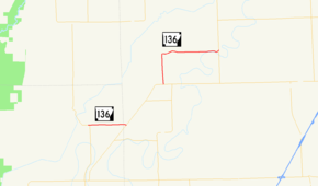
Highway 136 (AR 136, Ark. 136, Hwy. 136) is an east–west state highway in northeast Arkansas. The route of 7.87 miles (12.67 km) runs from Highway 135 near Rivervale east across Highway 140 to Highway 77 near Etowah.[2][3]
| ||||
|---|---|---|---|---|
 | ||||
| Route information | ||||
| Maintained by ArDOT | ||||
| Length | 7.87 mi[1] (12.67 km) | |||
| Major junctions | ||||
| West end | ||||
| East end | ||||
| Location | ||||
| Counties | Poinsett, Mississippi | |||
| Highway system | ||||
| ||||

Route description
Highway 136 begins at Highway 135 east of Rivervale. The route runs east to concur northeasterly with Highway 140. The route continues alone to Etowah, where it passes the Garden Point Cemetery and Edward Samuel Wildy Barn, both listed on the National Register of Historic Places.[4] The highway turns east to terminate at Highway 77 at Carroll's Corner.
Major intersections
Mile markers reset at concurrencies.
| County | Location | mi[1] | km | Destinations | Notes |
|---|---|---|---|---|---|
| Poinsett | | 0.00 | 0.00 | Western terminus | |
| Mississippi | | 2.35 | 3.78 | Begin AR 140 overlap | |
| Etowah | 0.00 | 0.00 | End AR 140 overlap | ||
| Carroll's Corner | 5.52 | 8.88 | Eastern terminus | ||
1.000 mi = 1.609 km; 1.000 km = 0.621 mi
| |||||
gollark: And possibly morally wrong, depending on your views on some things.
gollark: Deliberately giving up ultimate cosmic power is really stupid.
gollark: Because they know things like "the best way to achieve goal X is Y".
gollark: Also, for a broad enough definition of "everything about the world", they are already nigh-omnipotent.
gollark: It wouldn't really help anything at all.
See also
References
- Planning and Research Division (March 28, 2012). "Arkansas Road Log Database". Arkansas State Highway and Transportation Department. Archived from the original (MBD) on June 23, 2011. Retrieved April 13, 2012.
- General Highway Map, Poinsett County, Arkansas (PDF) (Map). 1:62500. Cartography by Planning and Research Division. Arkansas State Highway and Transportation Department. November 20, 2009. Retrieved April 15, 2012.
- General Highway Map, Mississippi County, Arkansas (PDF) (Map). 1:62500. Cartography by Planning and Research Division. Arkansas State Highway and Transportation Department. January 11, 2010. Retrieved April 15, 2012.
- "National Register Information System". National Register of Historic Places. National Park Service. March 13, 2009.
External links
![]()
This article is issued from Wikipedia. The text is licensed under Creative Commons - Attribution - Sharealike. Additional terms may apply for the media files.