Arizona State Route 195
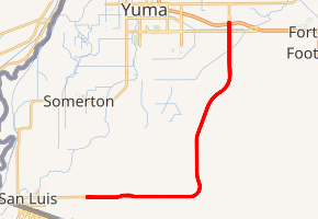
State Route 195 (SR 195) (nicknamed the Robert A. Vaughan Expressway by the Yuma Metropolitan Planning Organization in honor of their executive director at the time) is a 22.08-mile (35.53 km) state highway in Yuma County, Arizona, United States, that serves the Yuma area. It begins in Yuma east of downtown, intersecting with Interstate 8 (I‑8) and heads south and then west, coming to an end at the intersection with Avenue E½ near San Luis.
| ||||
|---|---|---|---|---|
| Robert A. Vaughan Expressway | ||||

SR 195 highlighted in red | ||||
| Route information | ||||
| Maintained by ADOT | ||||
| Length | 22.08 mi[1] (35.53 km) | |||
| Existed | 2009–present | |||
| Major junctions | ||||
| South end | Avenue E½ near San Luis | |||
| North end | ||||
| Location | ||||
| Counties | Yuma | |||
| Highway system | ||||
| ||||
Route description
SR 195 exists as mainly a divided highway that has been designed to be upgraded to a freeway in the future.
History
The only connection from I-8 to the San Luis Port of Entry was US 95, which runs as a surface street through the downtown business districts of Yuma, San Luis and Somerton. The area has experienced significant population growth since the 2000 Census. In the period from 2000–2005, the city of Yuma grew in population by 9.3%, the city of San Luis grew by 41.3%, and the town of Somerton grew by 38.6%,[2] and anticipation that the growth trend will continue has fueled concerns about increasing traffic congestion. Additionally, the Yuma Metropolitan Planning Organization (YMPO) has estimated that commercial truck traffic through the San Luis port to increase to over 12,000 daily by 2015.
Planning for the construction of SR 195 was implemented in response to these concerns. As of 1999, YMPO has secured an agreement with the state Department of Transportation to assist with funding for the project. In addition to addressing traffic concerns for the area, the highway will provide access for a proposed new port of entry east of San Luis. YMPO envisions these projects, along with potential expansion of cargo operations at the Yuma International Airport, as being parts of a concerted effort to increase the area's importance in regional and international trade and commerce. SR 195 was planned on November 15, 2002.
Construction of the northern end of SR 195 began in late October 2007, and was completed September 2009.
Junction list
The entire route is in Yuma County.
| Location | mi[1] | km | Destinations | Notes | |
|---|---|---|---|---|---|
| | 5.50 | 8.85 | Avenue E½ to US 95 | Temporary southern terminus; road continues as Juan Sanchez Boulevard | |
| Yuma | 26.95 | 43.37 | |||
| 27.61 | 44.43 | Northern terminus; I-8 exit 7 | |||
| 1.000 mi = 1.609 km; 1.000 km = 0.621 mi | |||||
See also
References
- Arizona Department of Transportation. "2013 ADOT Highway Log" (PDF). Retrieved January 22, 2016.
- "Annual Estimates of the Population for All Incorporated Places in Arizona". 2005 Population Estimates. U.S. Census Bureau, Population Division. June 21, 2006. Archived from the original (CSV) on October 12, 2010. Retrieved November 14, 2006.
External links
| Wikimedia Commons has media related to Arizona State Route 195. |
