Arago, Oregon
Arago is an unincorporated community in Coos County, Oregon, on the Coquille River, about 6 miles (10 km) south of Coquille. The area's elevation is 30 feet (9 m).[1] The Coquille Rural Fire District provides firefighting services.[2] The Coos County Sheriff and Myrtle Point police provide law enforcement services.
Arago, Oregon | |
|---|---|
 Arago Location within the state of Oregon  Arago Arago (the United States) | |
| Coordinates: 43°06′07″N 124°11′32″W | |
| Country | United States |
| State | Oregon |
| County | Coos |
| Elevation | 30 ft (9 m) |
| Time zone | UTC-8 (Pacific (PST)) |
| • Summer (DST) | UTC-7 (PDT) |
| GNIS feature ID | 1117024 |
History
The Arago post office was named for Cape Arago, which in turn was named for French physicist and geographer François Arago.[3] The previously suggested name of Halls Prairie was disapproved by postal authorities.[3]
gollark: GTech™ can also set up orbital nutritional bombardment streams with food shipped from the lunar farms.
gollark: How do they get around the square cube law?
gollark: How large are these giant-children?
gollark: Interesting!
gollark: What's your question exactly?
References
- "Arago". Geographic Names Information System (GNIS). United States Geological Survey. November 28, 1980. Retrieved May 4, 2016.
- "Coquille Fire Department". City of Coquille. Retrieved May 4, 2016.
- McArthur, Lewis A.; Lewis L. McArthur (2003) [1928]. Oregon Geographic Names (Seventh ed.). Portland, Oregon: Oregon Historical Society Press. pp. 29, 159. ISBN 0-87595-277-1.
Municipalities and communities of Coos County, Oregon, United States | ||
|---|---|---|
| Cities | 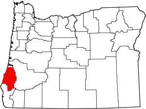 Coos County map | |
| CDPs | ||
| Unincorporated communities | ||
| Ghost town | ||
| Indian reservations | ||
| Footnotes | ‡This populated place also has portions in an adjacent county or counties | |
This article is issued from Wikipedia. The text is licensed under Creative Commons - Attribution - Sharealike. Additional terms may apply for the media files.