Apple Valley Airport (California)
Apple Valley Airport (IATA: APV, ICAO: KAPV, FAA LID: APV) is a public airport three miles (4.8 km) north of Apple Valley in San Bernardino County, California. The airport has two runways and is used for general aviation. It opened around 1970.
Apple Valley Airport | |||||||||||||||
|---|---|---|---|---|---|---|---|---|---|---|---|---|---|---|---|
_(2).jpg) | |||||||||||||||
| Summary | |||||||||||||||
| Airport type | Public | ||||||||||||||
| Location | Apple Valley, California | ||||||||||||||
| Elevation AMSL | 3,062 ft / 933 m | ||||||||||||||
| Coordinates | 34°34′31.2″N 117°11′10.3″W | ||||||||||||||
| Runways | |||||||||||||||
| |||||||||||||||
Past airline service
The first airline flights to Apple Valley were to the old airport 34.528°N 117.215°W by Air West predecessor Bonanza Air Lines from the late 1950s until 1966: DC-3s, then Fairchild F-27s.
From 1970 to 1973 Apple Valley was served by Air West and successor Hughes Airwest F-27s to Las Vegas, Riverside, Ontario and Los Angeles (LAX). In 1979 commuter airline Inland Empire Airlines scheduled Swearingen Metros to Ontario, Los Angeles, Bullhead City and Las Vegas.[2]
Facilities
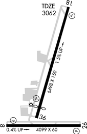
Diagram
The airport has two runways:
- 18/36: 6,498 x 150 ft (1,981 x 46 m) Asphalt
- 8/26: 4,099 x 60 ft (1,249 x 18 m) Asphalt
gollark: I see. Well, I'll consider doing this.
gollark: 10 what? Samples?
gollark: I'm not sure how low I could make the time reasonably be without either having to space the frequencies out a lot to keep them distinguishable or making it sound staticy.
gollark: Well, that should be easier, I can just pregenerate... 0.1 second blocks of various frequencies, or something.
gollark: Ah, hmm.
References
- FAA Airport Master Record for APV (Form 5010 PDF), effective 2009-08-27.
- http://www.departedflights.com, Nov. 15, 1979 Inland Empire map
External links
| Wikimedia Commons has media related to Apple Valley Airport (California). |
- FAA Terminal Procedures for APV, effective August 13, 2020
- Resources for this airport:
- FAA airport information for APV
- AirNav airport information for KAPV
- ASN accident history for APV
- FlightAware airport information and live flight tracker
- SkyVector aeronautical chart for KAPV
Airports in the Inland Empire | ||
|---|---|---|
| Commercial airports |  | |
| Towered general aviation airports | ||
| Non-towered general aviation airports | ||
| Military airports | ||
This article is issued from Wikipedia. The text is licensed under Creative Commons - Attribution - Sharealike. Additional terms may apply for the media files.