Apátfalva
Apátfalva is a village in Csongrád County, in the Southern Great Plain region of southern Hungary.
Apátfalva | |
|---|---|
| Country | |
| County | Csongrád |
| Area | |
| • Total | 53.77 km2 (20.76 sq mi) |
| Population (2015) | |
| • Total | 2,920[1] |
| • Density | 54.3/km2 (141/sq mi) |
| Time zone | UTC+1 (CET) |
| • Summer (DST) | UTC+2 (CEST) |
| Postal code | 6931 |
| Area code(s) | 62 |
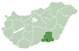
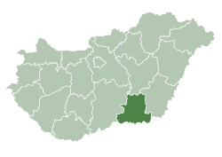
Location of Csongrád County in Hungary
Geography
It covers an area of 53.77 km2 (21 sq mi) and has a population of 2290 people (2015).[1]
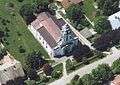 Saint Michael's church, Apátfalva
gollark: I can't be bothered to write the reminder thingy code, so PRs for that are extremely welcome.
gollark: Thanks!
gollark: Because PRs are welcome.
gollark: What?
gollark: <@738361430763372703> PRs welcome!
References
- Gazetteer of Hungary, 1st January 2015. Hungarian Central Statistical Office. 3 September 2015
| Cities with county rights |
|   |
|---|---|---|
| Towns | ||
| Large villages | ||
| Villages |
| |
| Other topics |
| |
This article is issued from Wikipedia. The text is licensed under Creative Commons - Attribution - Sharealike. Additional terms may apply for the media files.