Antanimbary
Antanimbary is a town and commune (Malagasy: kaominina) in Madagascar. It belongs to the district of Maevatanana, which is a part of Betsiboka Region. The population of the commune was estimated to be approximately 3,000 in 2001 commune census.[2]
Antanimbary | |
|---|---|
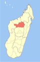
 Antanimbary Location in Madagascar | |
| Coordinates: 17°11′S 46°51′E | |
| Country | |
| Region | Betsiboka |
| District | Maevatanana |
| Elevation | 268 m (879 ft) |
| Population (2001)[2] | |
| • Total | 3,000 |
| Time zone | UTC3 (EAT) |
Antanimbary has a riverine harbour. Only primary schooling is available. The majority 60% of the population of the commune are farmers, while an additional 25% receives their livelihood from raising livestock. The most important crops are rice and raffia palm, while other important agricultural products are cassava and sweet potatoes. Services provide employment for 5% of the population. Additionally fishing employs 10% of the population.[2]
References and notes
- Estimated based on DEM data from Shuttle Radar Topography Mission
- "ILO census data". Cornell University. 2002. Retrieved 2008-03-05.
| Kandreho |
|  |
|---|---|---|
| Maevatanana | ||
| Tsaratanana | ||
gollark: What the 🐝 is that file FROM?
gollark: Hmm.
gollark: Time in what units?
gollark: I don't mind it AWFULLY, but it is a bad language, and more to the point the ecosystem means anything written it will decay over a few months.
gollark: MangoDB is much better.
This article is issued from Wikipedia. The text is licensed under Creative Commons - Attribution - Sharealike. Additional terms may apply for the media files.