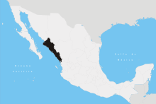
Angostura Municipality, Sinaloa
Angostura Municipality is a municipality in Sinaloa in northwestern Mexico.[2] Its seat is the city of Angostura.
Angostura Municipality Municipio de Angostura | |
|---|---|
 Seal | |
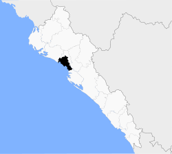 Location of the municipality in Sinaloa | |
| Coordinates: 25°21′54″N 108°09′43″W | |
| Country | |
| State | |
| Seat | Angostura |
| No. of Sindicaturas | 7 |
| Foundation | 1916 |
| Government | |
| • Municipal president | José Manuel Valenzuela López |
| Area | |
| • Total | 1,447.63 km2 (558.93 sq mi) |
| Population (2010) | |
| • Total | 44,993[1] |
| Time zone | UTC-7 (Mountain Standard Time) |
| • Summer (DST) | UTC-6 (Mountain Daylight Time) |
| Website | Official website |
It stands at 25°21′54″N 108°09′43″W.
According to 2010 census, it had a population of 44,993 inhabitants.
Political subdivision
Angostura Municipality is subdivided in 7 sindicaturas:
- La Ilama
- Colonia Agrícola México
- Gato de Lara
- Alhuey
- Puro Campo Plata
- La Reforma
- La Colonia Agrícola Independencia
gollark: It's not a hard problem. I'm not doing it in my head.
gollark: But somehow SO MANY PEOPLE don't get it. They just say "HELP ME IT IS DIFFICULT MATHS IS THIS VIRUS" or "WHAT IS THIS I DO NOT KNOW MATHS WHAT IS SEMIPRIME" and stuff.
gollark: I thought "well, this is an easy problem, you just need to duckduckgo 'factorize number' or use the `factor` command".
gollark: You know potatOS? To uninstall it, you need to solve a simple problem to stop automatic uninstallation (computers can do it easily but due to technical things user code can't actually *read* the problem it prints). Specifically, it generates a 10-digit semiprime and asks you to factorize it.
gollark: Never underestimate people's stupidity.
References
- "Main results by locality 2010". INEGI. 2010.
- "-". Enciclopedia de los Municipios de México. Instituto Nacional para el Federalismo y el Desarrollo Municipal. Archived from the original on January 28, 2007. Retrieved January 11, 2010.
Culiacán (capital) | ||
| Municipalities and (municipal seats) |
|  |
This article is issued from Wikipedia. The text is licensed under Creative Commons - Attribution - Sharealike. Additional terms may apply for the media files.