Alpirsbach
Alpirsbach (German: [ˈalpɪʁsbax] (![]()
Alpirsbach | |
|---|---|
.jpg) Alpirsbach, June 2017 | |
 Coat of arms | |
Location of Alpirsbach 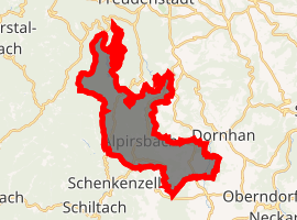
| |
 Alpirsbach 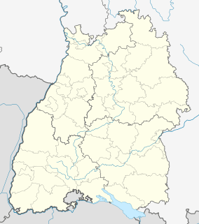 Alpirsbach | |
| Coordinates: 48°20′46″N 8°24′14″E | |
| Country | Germany |
| State | Baden-Württemberg |
| Admin. region | Karlsruhe |
| District | Freudenstadt |
| Subdivisions | 6 |
| Area | |
| • Total | 64.55 km2 (24.92 sq mi) |
| Elevation | 441 m (1,447 ft) |
| Population (2018-12-31)[1] | |
| • Total | 6,304 |
| • Density | 98/km2 (250/sq mi) |
| Time zone | CET/CEST (UTC+1/+2) |
| Postal codes | 72271–72275 |
| Dialling codes | 07444 |
| Vehicle registration | FDS |
| Website | www |
History
Alpirsbach delevoped as a market town around Alpirsbach Abbey,[2] a Benedictine monastery founded in 1095.[3] The monastery and its holdings were ceded to the Duchy of Württemberg by the Peace of Westphalia. In 1810, the by-then Kingdom of Württemberg made Alpirsbach the seat of a district office, but three years later it was assigned to Oberamt Oberndorf. Alpirsbach received town privileges in 1869 and was connected by railroad in 1886. The township was reassigned to the district of Freudenstadt in 1938. After World War II, it began expanding along the steep mountain slopes of the Kinzig river.[2]
Geography
The township (Stadt) covers an area of 64.55 square kilometers (24.92 sq mi) of the Freudenstadt district, within the state of Baden-Württemberg and the Federal Republic of Germany. Alpirsbach is physically located in the upper Kinzig valley, in the Central Black Forest, but also in the Upper Gäu at the municipal area's western extremity. The Kinzig marks the township's lowest elevation, 399 meters (1,309 ft) above sea level NN, while its highest, 800 meters (2,600 ft) NN, is in the mountainous northwest.[2]
The Glaswiesen und Glaswald Federally-protected nature reserve is located within Alpirsbach.[2]
Politics
Alpirsbach is twinned with the French commune of Neuville-sur-Saône.[4]
Coat of arms
The municipal coat of arms for Alpirsbach displays a crosier in golden upon a field of azure. This device was originally the coat of arms of Alpirsbach Abbey from the 15th century until its dissolution, and came to represent Alpirsbach in 1827. The coat of arms was approved by the Freudenstadt district office on 13 August 1976, though it had been in official use since 1953.[2]
Transportation
Alpirsbach is connected by the B294 and B462 federal highways.[2]
External links
| Wikimedia Commons has media related to Alpirsbach. |
- Official website (in German)
- Alpirsbach: pictures
References
- "Bevölkerung nach Nationalität und Geschlecht am 31. Dezember 2018". Statistisches Landesamt Baden-Württemberg (in German). July 2019.
- "Alpirsbach". LEO-BW (in German). Baden-Württemberg. Retrieved 16 June 2020.
- Harter, Hans. "Benediktinerabtei Alpirsbach - Geschichte". Klöster in Baden-Württemberg (in German). Baden-Württemberg State Archive. Retrieved 16 June 2020.
- "Partnerstadt Neuville sur Saone" (in German). Township of Alpirsbach. Retrieved 16 June 2020.
Important cities and tourist sites in | |||||||
|---|---|---|---|---|---|---|---|
| Major cities | |||||||
| Other tourist destinations | |||||||
| Landscapes | |||||||
| Neighbouring areas |
| ||||||
Towns and municipalities in Freudenstadt (district) | ||
|---|---|---|
Coat of arms | ||
| Authority control |
|
|---|