Allur mandal, Nellore district
Allur mandal is one of the 46 mandals in Nellore district of the Indian state of Andhra Pradesh. It is under the administration of Kavali revenue division and the headquarters are located at Allur.[1]
Allur Mandal | |
|---|---|
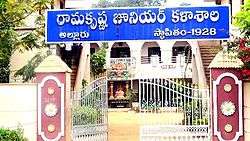
 Ramakrishna Junior College Entrance | |
.svg.png) Allur Mandal Location in Andhra Pradesh, India  Allur Mandal Allur Mandal (India) | |
| Coordinates: 14.68°N 80.06°E | |
| Country | |
| State | Andhra Pradesh |
| District | Nellore |
| Area | |
| • Total | 177.73 km2 (68.62 sq mi) |
| Population (2011)[1] | |
| • Total | 52,602 |
| • Density | 300/km2 (770/sq mi) |
| Languages | |
| • Official | Telugu |
| Time zone | UTC+5:30 (IST) |
| PIN | 524315 |
| Telephone code | +91-8622 |
| Sex ratio | 1009:1000 ♂/♀ |
Geography
Allur mandal is bounded by Bogole Mandal towards North, Vidavalur Mandal towards South, Dagadarthi Mandal towards west Kodavalur Mandal towards South.[1][2] Allur is located at 14°41′N 80°3′E.[3]
Government
Allur was also originally part of Nellore taluk. Kovur taluk was created from Nellore in 1910 and Allur became part of it. These taluks were reorganized as mandals in 1985 and Allur became a mandal.[4]
Towns and villages
As of 2011 census, the mandal has 15 settlements and all are villages.[1]
The settlements in the mandal are listed below:
- Allur
- Allurpeta
- Ananthabotlavari kandrika
- Batrakagollu
- Beeramgunta
- Gogulapalle (East and West)
- Graddagunta
- Indupuru
- Isakapalle
- Kalambotla Khandrika
- North Amuluru
- North Mopuru
- Purini
- Singapeta
- Velicherla
Demographics
As of 2011 the population of Allur mandal was 52,602 with 74,853 households. Male population is 26,272 and females are 26,330 and children are 5,622. The average literacy rate stands at 63.51% with 29,836 literates.[1]:229
| Census Division | Number of houses | Population | Children(0-6) | Sex Ratio | Children Sex Ratio | Male literacy | Female literacy | |
|---|---|---|---|---|---|---|---|---|
| 1 | Allur | 3,239 | 11,656 | 10.25% | 1021 | 940 | 73.84% | 64.08% |
| 2 | Allurpeta | 2,173 | 6,630 | 10.47% | 1037 | 1081 | 73.14% | 65.41% |
| 3 | Ananthabotlavari kandrika | uninhabited | ||||||
| 4 | Batrakagollu | 520 | 1,749 | 8.92% | 999 | 1026 | 62.78% | 49.06% |
| 5 | Beeramgunta | 557 | 1,898 | 9.59% | 1011 | 1022 | 74.82% | 62.99% |
| 6, 7 | Gogulapalle (East and West) | 1,253 | 4,384 | 9.99% | 970 | 1076 | 69.81% | 53.31% |
| 8 | Graddagunta | 163 | 616 | 11.36% | 962 | 892 | 74.73% | 57.99% |
| 9 | Indupuru | 687 | 2,524 | 10.62% | 1054 | 1144 | 65.67% | 55.82% |
| 10 | Isakapalle | 2,823 | 10,041 | 12.22% | 968 | 862 | 63.17% | 48.06% |
| 11 | Kalambotla Khandrika | uninhabited | ||||||
| 12 | North Amuluru | 414 | 1,671 | 11.55% | 961 | 804 | 70.87% | 56.89% |
| 13 | North Mopuru | 1,177 | 4,151 | 10.14% | 1018 | 846 | 65.99% | 55.65% |
| 14 | Purini | 897 | 3,001 | 9.56% | 980 | 993 | 66.33% | 53.35% |
| 15 | Singapeta | 854 | 2,955 | 12.01% | 1005 | 940 | 72.35% | 60.89% |
| 16 | Velicherla | 96 | 326 | 9.51% | 906 | 824 | 70.13% | 56.14% |
See also
References
- "District Census Handbook – Sri Potti Sriramulu Nellore" (PDF). Census of India. The Registrar General & Census Commissioner. pp. 25, 228. Retrieved 27 August 2016.
- "Guntur District Mandals" (PDF). Census of India. pp. 87, 110. Retrieved 19 January 2015.
- "Falling Rain Genomics". Retrieved 29 August 2016.
- Boswell, John Alexander Corrie. A Manual of the Nellore District in the Presidency of Madras. Government Press. p. 335,336. Retrieved 30 August 2016.