Allmersbach
Allmersbach im Tal is a municipality in the Rems-Murr district of Baden-Württemberg, Germany.
Allmersbach im Tal | |
|---|---|
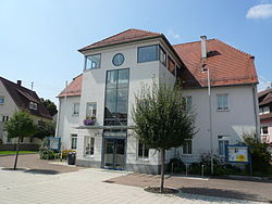 Allmersbach town hall | |
 Coat of arms | |
Location of Allmersbach im Tal within Rems-Murr-Kreis district 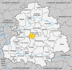 | |
 Allmersbach im Tal  Allmersbach im Tal | |
| Coordinates: 48°54′23″N 09°28′08″E | |
| Country | Germany |
| State | Baden-Württemberg |
| Admin. region | Stuttgart |
| District | Rems-Murr-Kreis |
| Area | |
| • Total | 7.95 km2 (3.07 sq mi) |
| Elevation | 286 m (938 ft) |
| Population (2018-12-31)[1] | |
| • Total | 4,840 |
| • Density | 610/km2 (1,600/sq mi) |
| Time zone | CET/CEST (UTC+1/+2) |
| Postal codes | 71573 |
| Dialling codes | 07191 |
| Vehicle registration | WN, BK |
| Website | www |
History
The municipality of Allmersbach im Tal was formed on 1 January 1972, as part of the 1968-75 Baden-Württemberg municipal reforms, by the merging of the towns of Allmersbach and Heutensbach.[2]
Geography
The municipality (Gemeinde) of Allmersbach lies at the center of the Rems-Murr district of Baden-Württemberg, one of the 16 States of the Federal Republic of Germany. Allmersbach is physically located in the Neckar basin and the southwest edge of the Backnanger Bucht. The municipal area also includes portions of the Schurwald and Welzheim Forest. Elevation above sea level in the municipal area ranges from a high of 462 meters (1,516 ft) Normalnull (NN) to a low of 414 meters (1,358 ft) NN.[2]
The Federally-protected Sommerrain nature reserve is located in Allmersbach's municipal area.[2]
Politics
Allmersbach is in a municipal association (Verwaltungsgemeinschaft) with the city of Backnang and the municipalities of Althütte, Aspach, Auenwald, Burgstetten, Kirchberg an der Murr, Oppenweiler, and Weissach im Tal.[2]
Coat of arms
Allmersbach's coat of arms displays a crossbow, in red and with its trigger guard facing right, upon a field of silver. The crossbow is a motif that has been associated with Allmersbach since 1686, though it is not known why, and the tincture is taken from the arms of the County of Löwenstein, which had property in the town. The coat of arms was approved for official use and a corresponding municipal flag issued by the Federal Ministry of the Interior on 16 September 1965.[2]
Transportation
Allermsbach is connected to German's network of roadways by its local Landesstraßen and Kreisstraßen. Local public transportation is provided by the Verkehrs- und Tarifverbund Stuttgart.[2]
References
- "Bevölkerung nach Nationalität und Geschlecht am 31. Dezember 2018". Statistisches Landesamt Baden-Württemberg (in German). July 2019.
- "Allmersbach im Tal". LEO-BW (in German). Baden-Württemberg. Retrieved 24 July 2020.
External links
- Official website

| Authority control |
|
|---|