Alfalfa, Alabama
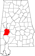
Alfalfa was an unincorporated community in Marengo County, Alabama, United States.[1] It has since been annexed into the adjacent city of Demopolis. Alfalfa had a post office at one time, but it no longer exists.[2]
Alfalfa, Alabama | |
|---|---|
 Alfalfa, Alabama Location within the state of Alabama  Alfalfa, Alabama Alfalfa, Alabama (the United States) | |
| Coordinates: 32°30′37.48″N 87°45′52.02″W | |
| Country | United States |
| State | Alabama |
| County | Marengo |
| Elevation | 144 ft (44 m) |
| Time zone | UTC-6 (Central (CST)) |
| • Summer (DST) | UTC-5 (CDT) |
| Area code(s) | 334 |
Geography
Alfalfa is located at 32.51041°N 87.76445°W and has an elevation of 144 feet (44 m).[1]
Demographics
Alfalfa never reported a population figure separately on the U.S. Census as an unincorporated community on the U.S. Census according to the census returns from 1850[3]-2010.[4] It has since been annexed into Demopolis.
gollark: I should add recommended system specs to clarify this.
gollark: That should be fine too.
gollark: It might be able to run on less than a megabyte, I haven't tested it.
gollark: (before you complain, GHC allocates something like a tibibyte at startup)
gollark: CC doesn't limit RAM, but probably a few terabytes is enough.
References
- U.S. Geological Survey Geographic Names Information System: Alfalfa, Alabama
- U.S. Geological Survey Geographic Names Information System: Alfalfa Post Office (historical)
- http://www2.census.gov/prod2/decennial/documents/1850c-11.pdf, 1850 Census (places)
- http://www.census.gov/prod/cen2010/cph-1-2.pdf, 2010 AL Census
This article is issued from Wikipedia. The text is licensed under Creative Commons - Attribution - Sharealike. Additional terms may apply for the media files.
