Alexandre Vuillemin
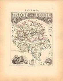
Alexandre Vuillemin (1812-1880) was a prominent 19th century French cartographer and editor based in Paris.[1] He produced a number of atlases, and his maps are noted for the frequent use of extensive margin illustrations – vignettes, famous people, and views of cities. His atlases were popular, and many went through multiple editions.[2]

Despite a prolific cartographic career, not a lot is known of Vuillemin's life. He studied under the French cartographer Auguste Dufour (1798 - 1865),[3] and his atlases and maps are held by and available through many collections including the British Museum[4] and the University of Alabama Historical Maps of Europe Archive.[5] Vuillemin's most important works include his detailed, highly decorative large format Atlas Illustré de Géographie Commerciale et Industrielle as well as his many French Atlases.
Selected works
- Atlas illustré de géographie commerciale et industrielle
- Atlas illustré destiné à l'enseignement de la géographie élémentaire
- Atlas universel (1839, 1847 and 1871)
- Atlas de géographie ancienne et moderne à destination des pensionnats (Paris 1843)
- Atlas national illustré de la France (1845)
- Mappemonde (Paris 1856)
- Atlas du cosmos (1867)
- Atlas topographique de la France (1873)
- Atlas de géographie contemporaine (1875)
- Carte de la Baltique donnant le Sund, le golfe de Finlande (1854)
- La France et ses Colonies: Atlas illustré cent cartes dressées d’après les cartes de Cassini, du Dépot de la guerre, des Ponts-et-chaussées et de la Marine (1858 and 1870)
External Links to Works Available Online
- La France et ses Colonies, 1858. Link to 101 maps from the atlas “France and its Colonies” at Old Book Art
- University of Alabama University of Alabama Historical Maps of Europe Archive (1836-1850). Some of his maps of Europe.
References
Notes
- Goffart, p. 46.
- Tooley, p. 161.
- Goffart, p. 347.
- British Museum, 1882
- Available online. See "External Links to Works Available Online" above.
Bibliography
- British Museum “British Museum Catalogue of Printed Books” British Museum, 1882. London, England.
- Goffart, Walter “Historical atlases: the first three hundred years, 1570-1870” University Of Chicago Press, 2003. Chicago IL.
- Tooley, Ronald V. "Mapping of Australia" Holland Press, 1979.