Alberta City, Tuscaloosa
Alberta City, sometimes shortened as "the ABC" by locals,[1] is the name of a suburban area of Tuscaloosa, Alabama, United States. Alberta City is located in the northeastern portion of Tuscaloosa and is generally defined as encompassing the portions of the city east of U.S. Route 82 (McFarland Boulevard), west of Holt, south of the Black Warrior River and north of Veterans Memorial Parkway.
Alberta City | |
|---|---|
Tuscaloosa Suburb | |
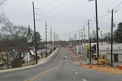 University Boulevard traveling east through Alberta City in 2003. Much of the suburb was reduced to vacant lots after the tornado outbreak of 2011 | |
| Coordinates: 33°12′25″N 87°30′27″W | |
| Country | United States |
| State | Alabama |
| City | Tuscaloosa |
| Elevation | 299 ft (91 m) |
| Time zone | UTC-6 (CST) |
| • Summer (DST) | UTC-5 (CDT) |
| ZIP Codes | 35404 |
| Area code(s) | 205, 659 |
History
With its founding in 1912 and much of its early development tracing to the early 20th Century, what is present-day Alberta City was annexed into Tuscaloosa on September 21, 1948.[2]
On April 27, 2011, Alberta City suffered the heaviest damage from a tornado that destroyed 12% of greater Tuscaloosa, including residences, churches, and stores. The suburb's landscape was changed significantly as numerous properties, homes, and businesses were completely destroyed and left as flat vacant lots after demolitions. Two police stations, a postal office, and elementary, middle, and primary day care schools were all damaged beyond repair or destroyed. Alberta City has undergone slow, gradual reconstruction ever since, largely due to revitalization efforts from the Tuscaloosa city government and from private investors and businesses seeing potential in the area due to its close proximity to the University of Alabama's main campus.[3][4]
Demographics
Alberta City never reported a population separately as an unincorporated community on the U.S. Census according to the census returns from 1850[5] until its annexation into Tuscaloosa in 1948.[6]
Infrastructure
Transportation
The neighborhood is serviced by both Alabama State Route 215 (University Boulevard) and U.S. Route 82 (McFarland Boulevard). Public transportation is provided via public bus serviced by the Tuscaloosa Transit Authority's Holt Route.[7]
See also
- Cottondale, Alabama — an adjacent unincorporated community in Tuscaloosa County
- Holt, Alabama — a nearby unincorporated community in Tuscaloosa County
References
- Taylor, Stephanie (2010-05-19). "Gang tension cited in mass shooting". Tuscaloosa News. Archived from the original on 2019-04-14. Retrieved 2019-04-14.
- "Annexation ballot brings 6,000 into municipality". The Tuscaloosa News. September 22, 1948. p. 1. Retrieved May 4, 2011.
- KPS Group (February 19, 2007). The Greater Alberta Community. Tuscaloosa Department of Planning and Zoning. p. 3. Archived from the original on July 17, 2011. Retrieved 2009-08-02.
- "'It's time' : Eight years after Tuscaloosa tornado, concrete slabs, foundations remain in violation of city law". Tuscaloosa News. 28 April 2019. Retrieved 29 April 2019.
- http://www2.census.gov/prod2/decennial/documents/1850c-11.pdf, 1850 Census (places)
- http://www.census.gov/prod/www/decennial.html
- Tuscaloosa Transit Authority. "Tuscaloosa Transit Authority : Route Information". Archived from the original on 2009-10-23. Retrieved 2009-08-02.