Alameda Street
Alameda Street is a major north-south thoroughfare in Los Angeles County, California. It is approximately 21 miles in length, running from Harry Bridges Boulevard in Wilmington; and through Carson, Compton, Lynwood, Watts, Vernon and Arts District to Spring and College in Chinatown. For much of its length, Alameda runs through present and former industrial corridors, and is paralleled by Southern Pacific Railway tracks.
| Length | 21 miles |
|---|---|
| South end | |
| Major junctions | |
| North end | College Street near Chinatown, Los Angeles |
Route description
Downtown and Chinatown

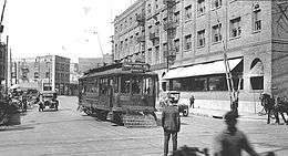
Alameda Street runs on the east side of the Old Plaza, Los Angeles, and once also ran along the westside of Old Chinatown. In the late 19th century, Alameda Street and Commercial Street were Los Angeles' original red-light district.[1] South of Union Station, Alameda Street enters Little Tokyo and the former Warehouse District, now the Arts District. At one time, a lot on Alameda and 8th was a haven for free-speech demonstrations.[2]
South of Downtown
At 27th Street, Alameda Street splits into two roadways divided by the 10-mile (16 km) Mid-Corridor Trench: a local roadway on the east and the main Alameda Street to the west. Here, Alameda Street intersects with Slauson Avenue, Florence Avenue, Firestone Boulevard (former SR 42) and Imperial Highway. Each of these streets is grade-separated from the rail line. Though Alameda Street has interchanges with I-10, SR 91 and I-405, it does not have an interchange with I-105 near Watts.
California State Route 47
Alameda Street is designated California State Route 47 between the California State Route 91 and Henry Ford Avenue. There are few at-grade crossings with other streets in this portion of Alameda, with Artesia Boulevard, Del Amo Boulevard, Carson Street, 223rd Street (at the San Diego Freeway/I-405 interchange) Sepulveda Boulevard, and Pacific Coast Highway (SR 1), all flying over Alameda while being connected to it with connector ramps. Alameda Street descends into a tunnel between California State 91 and Del Amo Boulevard, at which point the Alameda Corridor crosses from the east to the west of Alameda.
South of Henry Ford Avenue, Alameda Street continues for another 1.4 miles (2.3 km) in Wilmington before ending at Harry Bridges Boulevard (formerly B Street).
Southern Pacific Railroad

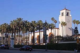
Alameda Street has a long history of Southern Pacific Railroad tracks running on or parallel to it. Before the building of Union Station, Southern Pacific trains would travel along Alameda between Naud Junction and the Southern Pacific Arcade Station on 5th Street. Though Southern Pacific eventually rerouted its downtown tracks to the LA River, Alameda still carries SP tracks between 27th Street and the Port of Los Angeles. This area is known as the Alameda Corridor. With the 2002 completion of the Alameda Corridor in a trench adjacent to Alameda, the trackage is now shared by the BNSF Railway and Union Pacific Railroad (Southern Pacific's company).[3] Los Angeles Union Station fronts onto Alameda Street.
History
Transit
Metro Local Line 202 runs along Alameda Street between Del Amo Boulevard and Pacific Coast Highway. Metro Local Line 58 formerly served Alameda Street between Union Station and Washington, but was discontinued in 2005.
Three Metro L Line Stations are located on Alameda Street: Little Tokyo/Arts District, Union Station, and Chinatown. Union Station is also served by the Red and Purple lines, as well as Metrolink and Amtrak.
References
- Estrada, William. The Los Angeles Plaza. p. 96. ISBN 0292782098.
- Estrada, William. The Los Angeles Plaza. p. 164. ISBN 0292782098.
- Redden, J. W.; Selig, E. T.; Zaremsbki, A. M. (February 2002). "Stiff track modulus considerations". RT&S: Railway Track & Structures. 98 (2): 25–30.