Alabama State Route 245
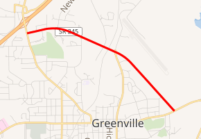
State Route 245 (SR 245) is a 3-mile-long (4.8 km) route that serves as a bypass to the northeast of Greenville between SR 10 and SR 185.
| ||||
|---|---|---|---|---|
| ||||
| Route information | ||||
| Maintained by ALDOT | ||||
| Length | 2.586 mi[1] (4.162 km) | |||
| Major junctions | ||||
| South end | ||||
| North end | ||||
| Location | ||||
| Counties | Butler | |||
| Highway system | ||||
| ||||

Route description
The southern terminus of SR 245 is located at its intersection with SR 10 to the east of downtown Greenville. From this point, the route travels in a northwesterly direction to its northern terminus at its intersection with SR 185 to the north of downtown Greenville.
Major intersections
The entire route is in Greenville, Butler County.
| mi[1] | km | Destinations | Notes | ||
|---|---|---|---|---|---|
| 0.000 | 0.000 | Southern terminus | |||
| 1.36 | 2.19 | ||||
| 2.586 | 4.162 | Northern terminus | |||
| 1.000 mi = 1.609 km; 1.000 km = 0.621 mi | |||||
gollark: Yes, but it would break things.
gollark: I mostly delete `node_modules` folders.
gollark: Try deleting your unfinished programming projects.
gollark: Are you using Windows GUI stuff or what?
gollark: Yes, I would "love" being unable to move at all utterly in a game?
References
- Milepost Map (Map). Alabama Department of Transportation. Archived from the original (PDF) on July 27, 2011. Retrieved March 29, 2011.
External links
- Alabama Department of Transportation county road maps for Butler (Adobe Acrobat reader required for maps; enlargement of maps necessary for legibility)
This article is issued from Wikipedia. The text is licensed under Creative Commons - Attribution - Sharealike. Additional terms may apply for the media files.