Alabama State Route 127
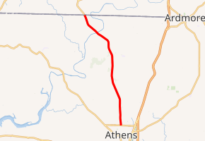
State Route 127 (SR 127) is a 13.510-mile (21.742 km) state highway that serves the north-central areas of Limestone County in the north-central part of the U.S. state of Alabama. SR 127 intersects SR 99 at its southern terminus in Athens and continues as Tennessee State Route 166 (SR 166) upon entering Tennessee at its northern terminus.
| ||||
|---|---|---|---|---|

| ||||
| Route information | ||||
| Maintained by ALDOT | ||||
| Length | 13.510 mi[1] (21.742 km) | |||
| Major junctions | ||||
| South end | ||||
| North end | ||||
| Location | ||||
| Counties | Limestone | |||
| Highway system | ||||
| ||||
Route description
SR 127 begins at an intersection with SR 99 (running concurrently with Elm Street) opposite Jefferson Street in northern Athens.[2] From this point, the highway travels in a northerly direction before turning in a northwesterly direction north of Elkmont.[3] SR 127 continues in its northwesterly path in crossing the Elk River prior to reaching the Tennessee state line and continues as SR 166.[4]
Major intersections
The entire route is in Limestone County.
| Location | mi[1] | km | Destinations | Notes | |
|---|---|---|---|---|---|
| Athens | 0.000 | 0.000 | Southern terminus | ||
| | 13.510 | 21.742 | Tennessee state line; northern terminus | ||
| 1.000 mi = 1.609 km; 1.000 km = 0.621 mi | |||||
See also


References
- Milepost Map of Limestone County (PDF) (Map). Cartography by ALDOT Bureau of Transportation Planning, Survey & Mapping Division. Alabama Department of Transportation. 1999. Archived from the original (PDF) on 2008-06-25.
- Google (April 29, 2010). "SR-127 southern terminus" (Map). Google Maps. Google. Retrieved April 29, 2010.
- Google (April 29, 2010). "SR-127 at Elkmont" (Map). Google Maps. Google. Retrieved April 29, 2010.
- Google (April 29, 2010). "SR-127 northern terminus" (Map). Google Maps. Google. Retrieved April 29, 2010.
