Agios Kosmas
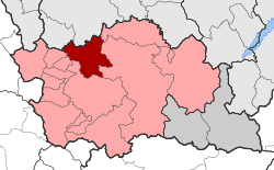
Agios Kosmas (Greek: Άγιος Κοσμάς) is a village, a community and a municipal unit of the Grevena municipality.[1] Before the 2011 local government reform it was an independent municipality.[2] The municipality was established in 1997 with the name Kosmas o Aitolos (Κοσμάς ο Αιτωλός), which was changed to Agios Kosmas in 2004. The seat of the municipality was in Megaro.[3] The 2011 census recorded 49 residents in the village, 75 residents in the community and 870 residents in the municipal unit.[1] The community of Agios Kosmas covers an area of 9.496 km2 while the municipal unit covers an area of 115.087 km2.[4] The village is named after the 18th-century saint Cosmas the Aetolian.
Agios Kosmas Άγιος Κοσμάς | |
|---|---|
 Agios Kosmas Location within the regional unit  | |
| Coordinates: 40°9.1′N 21°15′E | |
| Country | Greece |
| Administrative region | West Macedonia |
| Regional unit | Grevena |
| Municipality | Grevena |
| • Municipal unit | 115.087 km2 (44.435 sq mi) |
| Elevation | 962 m (3,156 ft) |
| Population (2011)[1] | |
| • Rural | 49 |
| • Municipal unit | 870 |
| • Municipal unit density | 7.6/km2 (20/sq mi) |
| Community | |
| • Population | 75 (2011) |
| • Area (km2) | 9.496 |
| Time zone | UTC+2 (EET) |
| • Summer (DST) | UTC+3 (EEST) |
| Postal code | 511 00 |
| Area code(s) | +30-2462-xxx-xxx |
| Vehicle registration | PNx-xxxx |
Administrative division
The municipal unit of Agios Kosmas consists of nine communities: Agios Kosmas, Dasyllio, Kalirachi, Kalloni, Kydonies, Kyparissi, Megaro, Oropedio and Trikorfo.
The community of Agios Kosmas consists of three settlements: Agios Kosmas, Ano Ekklisia and Ekklisia.
Population
According to the 2011 census, the population of the municipal unit of Agios Kosmas was 870 people, a decrease of almost 49% compared to the previous census of 2001.[1][4]
|
References
- "Απογραφή Πληθυσμού - Κατοικιών 2011. ΜΟΝΙΜΟΣ Πληθυσμός" (in Greek). Hellenic Statistical Authority.
- Kallikratis law Greece Ministry of Interior (in Greek)
- "EETAA local government changes". Retrieved 26 June 2020.
- "Population & housing census 2001 (incl. area and average elevation)" (PDF) (in Greek). National Statistical Service of Greece. Archived from the original (PDF) on 2015-09-21.