Afikpo South
Edda administratively designated by Nigeria as Afikpo South is a local government area in Ebonyi State, Nigeria. It is the homeland of a culturally distinct people known as the Eddics, who are misconstrued a sub-class of the dominant Igbo ethnic group of South East Nigeria. Eddish people are culturally distinct, but today their old language has gone extinct. They presently speak a dialectal form of Igbo with many words also borrowed from Efik and spoken with a very distinctive accent.
Eddaland (Afikpo South LGA) Edda, Eddska Edda Egbebu | |
|---|---|
LGA | |
| Motto(s): Never carried off by hawks | |
 Eddaland (Afikpo South LGA) Location in Nigeria | |
| Coordinates: 5°58′N 7°52′E[1] | |
| Country | |
| State | Ebonyi State |
| Headquarters | Nguzu Edda |
| HASC | NG.EB.AS |
| Government | |
| • Type | Local Government |
| Area | |
| • Total | 146 sq mi (378 km2) |
| Population (2006) | |
| • Total | 157,072[2] |
| Time zone | UTC+1 (WAT) |
| Postcode | 490 |
| Ethnicity | Eddic, Igbo, others |
Eddaland is composed of many autonomous communities and towns which include Ebunwana Edda, Nguzu Edda, Ekoli Edda, Owutu Edda, Amangwu Edda, Oso Edda, Etiti Edda, and Ogbu Edda. The local area headquarters Afikpo South being the Nigerian government designated administrative name for Eddaland is at Nguzu.
The names of Eddish towns often have Edda at their endings, as an addendum, designating their membership of the Eddic cultural common wealth and community of shared values. Each of the autonomous communities of Eddaland had been existing as small city states with each having its own monarch before Nigeria was carved up by British colonialists. These communities made up of about 72 villages today had been functioning as a confederation of small city states bounded by common heritage until 1867 when British colonialists enveloped Eddaland into the Country of Southern Nigeria. South Nigeria existed as different country from Northern Nigeria, both of which were amalgamated in 1914 to forge today’s Nigeria. The old city states of Eddaland still exist with monarchs that have no administrative functions; but are just cultural representatives of Edda communities.
The designation of Afikpo South was given to Eddaland when it was carved out of the old Afikpo Local Government Area in 1991 by the then Nigerian Federal Military Government. Successive legislators from the area have since fought to have its name changed to Edda Local Government Area in Nigeria's constitution so as to better reflect their heritage.
Due to a unique culture that values inclusiveness and integrity, Eddaland has a very serene atmosphere of calm and is so peaceful with so low level crime that even today, there exists only a few police stations/posts in the entire area. The pristine natural environment of undulating hills, springs and quiet small lakes and the calm and welcoming traditions of the Eddish people casts Eddaland as an ideal untouched rough diamond for development into a future world tourism destination.
[3][4][5] The local government is administered by an elected Chairman and councillors who are elected from their respective wards within the local government area. The first executive chairman was Chief Sonni Ogbuoji.
Eddaland is bordered by Unwana to the east; Akaeze to the west, Amasiri to the north, Afikpo to the north-east, Ohafia to the south, Nkporo to the south west, and Erei to the south-east[6]
It has an area of 378 km2 (146 sq mi) and a population of 157,072 at the 2006 census.
Weather, climate and vegetation: There are two distinctive seasons in this area; The rainy and dry seasons. The rainy seasons usually begin in early March and ends in October, to give way for the dry season. The dry season usually begins from October and ends in February. These two seasons are dependent on two prevailing winds-The North East trade wind or Dry Harmattan (also called The Tropical Continental) airmass, laden with dust from the Sahara Desert and the South West trade wind from the south Atlantic Ocean (also called The Tropical Maritime) air mass. Temperatures range from 20 °C to 38 °C during dry season and 16 °C to 28 °C during the rainy season. Average annual rainfall varies from 1750mm to 2250mm. The vegetation here is a parkland, with stunted trees and pockets of woodland and forest consisting of shrubs and large trees.
The economy here is generally subsistence with agriculture as the mainstay. But with a new vision based on inclusive education and technology now being embraced by Eddish royals for the Eddish people, Eddaland seems to be veering into a new trajectory of economic relevance.
The postal code of the area is 490.[7]
References
- "Edda: Nigeria". Geographical Names. Retrieved 15 October 2015.
- http://www.statoids.com/yng.html
- http://www.statoids.com/ung.html
- Suberu, Rotimi T. (1994) 1991 state and local government reorganizations in Nigeria Institute of African Studies, University of Ibadan, Ibadan, Nigeria, ISBN 978-2015-28-8
- Ajayi, Gboyega (2007) The military and the Nigerian state, 1966-1993: a study of the strategies of political power control Africa World Press, Trenton New Jersey, ISBN 1-59221-568-8
- http://www.doublegist.com/social-control-system-role-traditional-associations-edda/
- "Post Offices- with map of LGA". NIPOST. Archived from the original on 7 October 2009. Retrieved 2009-10-20.
State capital: Abakaliki | ||
| Local Government Areas | 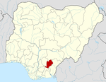 | |