Aetomilitsa
Aetomilitsa (Greek: Αετομηλίτσα, before 1927: Δέντσικο - Dentsiko,[2] Aromanian: Densko, Denicko) is a village in the Ioannina regional unit, Epirus, Greece. Since the 2011 local government reform it is part of the municipality Konitsa, of which it is a municipal unit.[3] Before 2011, it was an independent community.[2] The 2011 census recorded 432 residents in the village.[1] The community of Aetomilitsa covers an area of 51.297 square kilometres (19.806 sq mi).[4]
Aetomilitsa Αετομηλίτσα | |
|---|---|
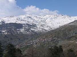
 View on Aetomilitsa village. Peaks of Gramos mountain visible in the background | |
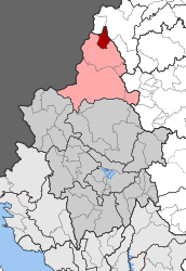
 Aetomilitsa Location within the regional unit  | |
| Coordinates: 40°18.6′N 20°51.3′E | |
| Country | Greece |
| Administrative region | Epirus |
| Regional unit | Ioannina |
| Municipality | Konitsa |
| • Municipal unit | 51.297 km2 (19.806 sq mi) |
| Highest elevation | 1,485 m (4,872 ft) |
| Lowest elevation | 1,385 m (4,544 ft) |
| Population (2011)[1] | |
| • Municipal unit | 432 |
| • Municipal unit density | 8.4/km2 (22/sq mi) |
| Time zone | UTC+2 (EET) |
| • Summer (DST) | UTC+3 (EEST) |
| Postal code | 440 15 |
| Area code(s) | +30-2655-xxx-xxx |
| Vehicle registration | INx-xxxx |
Geography
The village lies on the Gramos mountain. It is one of the highest communities in Greece situated at an altitude between 1,385 and 1,485 metres (4,544 and 4,872 ft). A glacial lake, Moutsalia Lake (Greek: Λίμνη Μουτσάλια) is situated 5 km as the crow flies or 13 km drive on a dirt road from Aetomilitsa.[5]
History
Aetomilitsa today and since its founding has been traditionally inhabited by native Aromanians (Vlachs) who are Orthodox Christians. For a time during the Greek Civil War (1946-1949), Aetomilitsa was the seat of the communist rebels, the so-called "Provisional Democratic Government".[6]
References
- "Απογραφή Πληθυσμού - Κατοικιών 2011. ΜΟΝΙΜΟΣ Πληθυσμός" (in Greek). Hellenic Statistical Authority.
- "EETAA local government changes". Retrieved 26 June 2020.
- Kallikratis law Greece Ministry of Interior (in Greek)
- "Population & housing census 2001 (incl. area and average elevation)" (PDF) (in Greek). National Statistical Service of Greece. Archived from the original (PDF) on 2015-09-21.
- "Fourwheel drive to Grammos - Lake Moutsalia". Retrieved 2020-01-06.
- Shrader, Charles R. (1999). The Withered Vine: Logistics and the Communist Insurgency in Greece, 1945-1949. Greenwood Publishing Group. p. 6. ISBN 9780275965440.