Adenbüttel
Adenbüttel is a municipality in the Gifhorn district in Lower Saxony, Germany. It is a member municipality of the Samtgemeinde Papenteich. The Municipality Adenbüttel includes the villages of Adenbüttel and Rolfsbüttel
Adenbüttel | |
|---|---|
 Coat of arms | |
Location of Adenbüttel within Gifhorn district 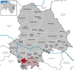  | |
 Adenbüttel 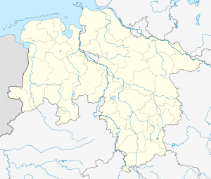 Adenbüttel | |
| Coordinates: 52°22′51″N 10°27′09″E | |
| Country | Germany |
| State | Lower Saxony |
| District | Gifhorn |
| Municipal assoc. | Papenteich |
| Subdivisions | 2 Ortsteile |
| Government | |
| • Mayor | Michael Heinrichs (SPD) |
| Area | |
| • Total | 13.71 km2 (5.29 sq mi) |
| Elevation | 74 m (243 ft) |
| Population (2018-12-31)[1] | |
| • Total | 1,765 |
| • Density | 130/km2 (330/sq mi) |
| Time zone | CET/CEST (UTC+1/+2) |
| Postal codes | 38528 |
| Dialling codes | 05304 |
| Vehicle registration | GF |
| Website | www.adenbuettel.de |
Geography
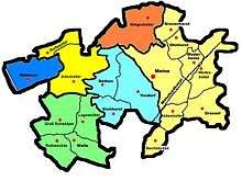
Neighbourhood
* distance from downtown
| City of Gifhorn (16 km) | ||||
| Municipality Didderse (3 km) | Municipality Rötgesbüttel (8 km) | |||
 |
Municipality Meine (4 km) | City of Wolfsburg (24 km) | ||
| Municipality Schwülper (3 km) | Rethen (2 km) | |||
| City of Braunschweig (16 km) |
Geographical position
Adenbüttel is situated north of Braunschweig, between the Harz and the Lüneburg Heath. However, administrative it belongs to the district of Gifhorn. Adenbüttel is around 4 km to the west to the German highway 4 (near Meine) and around 7 km to the north of the interchange Brunswick North (A2 /A391). Other bigger towns nearby are: Wolfsburg, Salzgitter, Wolfenbüttel, Gifhorn, Peine and Celle.
History
The first documentary mentioning of Adenbüttel was in the year 1226. In 1619 a church was erected, whose baseplate can yet be seen nowadays. In the first half of 20th century a potash mine existed near the village.
Politics
The last election for the community government took place on the 10 September 2006 with an election turnout of 73.39%. Since that day the district council consists as follows:
- CDU 5 Seats
- SPD 4 Seats
- Independent Party 2 Seats
References
| Authority control |
|
|---|