Abilene metropolitan area
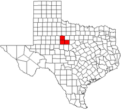
The Abilene metropolitan statistical area is a metropolitan area in west central Texas that covers three counties—Taylor, Jones, and Callahan. As of the 2010 census, the MSA had a population of 165,252 (though a 1 July 2016 estimate placed the population at 169,893).[1]
Abilene Metropolitan Area | |
|---|---|
| Abilene | |
 | |
| Country | United States |
| State(s) | Texas |
| Largest city | Abilene |
| Other cities |
|
| Area | |
| • Total | 2,757 sq mi (7,140 km2) |
| Population | |
| • Total | 169,893 |
| • Rank | 243rd in the U.S. |
| • Density | 62/sq mi (24/km2) |
Communities
Places with more than 100,000 people
- Abilene (Principal city)
Places with 5,000 to 100,000 people
- Dyess AFB
Places with fewer than 1,000 people
Demographics
As of the census[2] of 2000, there were 160,245 people, 58,475 households, and 40,799 families residing within the MSA. The racial makeup of the MSA was 81.52% White, 6.83% African American, 0.57% Native American, 1.07% Asian, 0.06% Pacific Islander, 7.78% from other races, and 2.19% from two or more races. Hispanic or Latino of any race were 17.15% of the population.
The median income for a household in the MSA was $32,023 and the median income for a family was $37,805. Males had a median income of $27,647 versus $19,523 for females. The per capita income for the MSA was $19,523.
Transportation
Traffic problems
There are a few areas in the MSA that are prone to traffic problems. These places are along the US 83 access roads (Clack and Danville) especially on the south side of town, near the mall, on Southwest Drive from Elm Creek to the Winters Freeway, and on S 14th near the Winters Freeway.
Major highways
Interstates


US highways


State highways


See also
- List of cities in Texas
- List of museums in West Texas
- Texas census statistical areas
- List of Texas metropolitan areas
References
- "Metropolitan and Micropolitan Statistical Areas". 2011 Population Estimates. United States Census Bureau, Population Division. 1 July 2017. Retrieved 18 September 2017.
- "U.S. Census website". United States Census Bureau. Retrieved 2008-01-31.