A847 road
The A847 road is one of the two principal roads of Islay in the Inner Hebrides off the west coast of mainland Scotland.
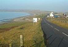
The A847 at Uiskentuie
| |
|---|---|
| Route information | |
| Length | 14.7 mi[1] (23.7 km) |
| Major junctions | |
| North end | Bridgend 55°46′55″N 6°14′56″W |
| South end | Portnahaven 55°40′51″N 6°30′23″W |
| Road network | |
It connects Bridgend, at a junction with the A846 road, with Portnahaven at the southern end of the Rinns of Islay peninsula. It is some 14 1⁄2 miles (23 km) long.
Settlements on or near the A847
North to South
- Bridgend
- Blackrock
- Bruichladdich
- Port Charlotte
- Nerabus (Nereabolls)
- Easter Ellister
- Portnahaven
gollark: Yes, this is known.
gollark: Allegedly.
gollark: Excellent, necessary data obtained.
gollark: I just had a great idea for telling who the author of #4 is which I am not telling you. Muahahaha.
gollark: ++remind 4d <@!319753218592866315> is like 2.2 bee/m³.
References
- "Driving directions to High St/A847". Google. Retrieved 23 September 2013.
A roads in Zone 8 of the Great Britain road numbering scheme | ||
|---|---|---|
This article is issued from Wikipedia. The text is licensed under Creative Commons - Attribution - Sharealike. Additional terms may apply for the media files.