A3071 road
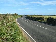
The A3071 is a minor 'A' road in the English county of Cornwall, which links St Just to Penzance and the A30.[1] It is 6.2 miles long.

| |
|---|---|
| Route information | |
| Length | 6.2 mi (10.0 km) |
| Major junctions | |
| West end | St. Just |
| East end | A30 & Penzance |
| Location | |
| Primary destinations | St. Just, Newbridge, Tremethick Cross & Penzance |
| Road network | |
History
In the early 19th-century, mines in the parish of St Just were flourishing but there were no natural harbours along the north coast. Mule trains, pack-horses or wagons with four horses carried copper and tin to the harbour at the stannary town of Penzance. The wagons often grounded at the ford in the village of Hallen Tachen and a report in The West Briton newspaper on 26 May 1843 indicated that a bridge was to be built at by Mr Edward Harvey of Penzance. The bridge was funded by the mining industry and Nicholas Holman who had transferred his foundry from Copperhouse, Hayle to Tregeseal in 1834. The two-span grade II listed bridge was a rebuild of an older bridge, from which the parapets and terminal refuges survive. The bridge is built of granite ashlar with granite dressings except for the rubble walls of the older bridge. The wider span is over the stream and a narrow span over the leat to Roskennals Mill. There is an inscription of ″EH″ on the north side and ″1843″ on the southern side.[2] The village of Hallen Tachen is now known as Newbridge.[3]
Turnpike
In 1863 the Penwith Turnpike Trust (later the Penzance and St Just Turnpike Trust) was formed. The road was the link between the mining region along the coast from St Just to Pendeen and carried heavy mining traffic to the harbour at the stannary town of Penzance.[4] The Turnpike included two branches,
- the current B3318 which leaves the A3071 at Deveral Common and crosses Boscaswell HIgher Downs. On Woon Gumpas Common the road splits with one branch reaching the north coast road at Trewellard and the other at Portheras Cross. Before the turnpike the original road left the A3071 at HIgher Tregerest, taking a steeper route over Dry Carn Hill.
- a road now known as Turnpike Road or New Road, leaving the A3071 at a road junction (grid reference SW381309) to Sancreed, serving the foundry at Nancherrow.[5]
The turnpike provided an easier route for the teams of four horses and wagons which had replaced pack mules.[6] A toll was charged to use the road, which was let by yearly auction. In 1882, for example, the winning bid for running the turnpike was £550 and at that time was let annually.[7] There was a continuation Act in 1884 and the Turnpike Trust closed in November 1885.[8]
Milestones
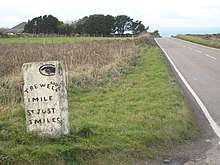
A number of milestones and guide stones mark the route, some still surviving in their original position. They are of two designs, the earlier ones which predate the Turnpike Trust have arched tops and the ones erected by the trust have pyramidal tops.[4] Some are listed,
- A3071
| Miles to Penzance | Photograph | Date | Description | Grade (if listed) |
|---|---|---|---|---|
| 1 | – | At grid reference SW45662997.[9] | ||
| 2 | – | At grid reference SW44023064.[9] | ||
| 3 | – | A rectangular granite stone 1 metre high with a truncated rectangular pyramid top, to the west of Tremayne Farm. The painted black inscription is ″3″, in a square recessed panel. (First listed on 9 July 2012 at grid reference SW4268631582).[10] | II | |
| – | Early 19th century | An early 19th century (probably 1819) guidepost the junction to an earlier road to Pendeen. It is a dressed granite monolith with a pyrimidal head and incised inscriptions at the front and rear. The front inscription reads ″SAINT″ over a hand pointer ″JUST ROAD and MORVAH″ and the rear inscription reads ″SAINT JUST TOWN 18-″. (First listed on 15 December 1988 at grid reference SW4268631582).[11] | II | |
| – | Early 19th century | Early 19th century guide post with incised inscriptions, with hand-pointers over the left-handed inscription ″St Just GP″. There is an Ordnance Survey bench mark under the right-handed inscription ″Pendeen″. Originally at (grid reference SW408318) and now at the current junction. (First listed on 15 December 1988 at grid reference SW4060531755). [12] | II | |
| 5 | – | Early 19th century | Early 19th century painted milestone, to the east of the former china clay works. The granite stone has a three-sided head and the Arabic numeral ″5″ in relief in a rectangular panel. (First listed on 15 December 1988 at grid reference SW3972832668).[13] | II |
| 5 | – | An early granite milestone, which predates the turnpike and is in its original position just to the east of the former china clay works. The stone is just over 1 m high, rectangular in plan with a rounded top and has black painted lettering. The inscription on the north face is ″FROM PENZ 5″. (First listed on 30 July 2012 at grid reference SW3953331139).[4] | II | |
| – | 1833 | 1833 granite stone at the junction of Turnpike Road and the road to Sancreed, with the following inscriptions on two sides. ″To Sancreed Church Town and Paul″ and ″Penzance Direct Road AD1833″. (First listed on 19 March 1979, at grid reference SW3812430987).[14] | II | |
| 6 | Small, painted granite guide stone with an arched head approximately 100m west of the road to Sancreed. The inscription reads ″From Penz. 6.″ (First listed on 19 March 1979, at grid reference SW3799830954).[15] | II | ||
| 6½ | – | 1836 | Painted granite stone with round-headed sides, at the junction with the B3306 to Land's End Airport and the A30, near Crows-an-Wra. There are carved pointed hands in oval panels and the incised lettering below is, ″To Penzance 61⁄2 miles. AD1836″ and ″To St Buryan 5 miles, To Lands End 6 miles″. (First listed on 19 March 1979, at grid reference SW3743930989).[16] | II |
- B3318

- A rectangular, roughly hewn, painted white stone with smoother carving at the corners to the east of Bal Farm. On the west face is a recessed, nearly square panel with a black painted '6' in relief. The stone has a pyramidal cap with a flat top. (First listed on 27 January 2012 at grid reference SW3858733468).[6]
- The 1863 stone is rectangular in plan, the white-painted stone has roughly hewn surfaces with smoother carving at the corners. Above is a pyramidal cap with a flat top. A recessed panel on the west face has a black painted number ′ 6 ′ in relief which is the distance to Penzance. (First listed on 10 September 2012 at grid reference SW3894034009)[8]
References
- "1 Inch Map of Land's End". Ordnance Survey. 1960. Retrieved 11 June 2019.
- Historic England & 1143820
- Thompson 2013, pp. 17–20
- Historic England & 1405977
- Thompson 2013, pp. 17
- Historic England & 1406916
- "Penzance And St Just Turnpike Roads". The Cornishman (231). 14 December 1882. p. 1.
- Historic England & 1405968
- OS Explorer 102 Land's End. Southampton: Ordnance Survey. 2015. ISBN 978 0 319 24304 6.
- Historic England & 1405971
- Historic England & 1158218
- Historic England & 1143855
- Historic England & 1143857
- Historic England & 1327827
- Historic England & 1039568
- Historic England & 1373929
Sources
- Historic England, "Newbridge Bridge (1143820)", National Heritage List for England, retrieved 11 June 2019
- A3071
- Historic England, "Guide Stone At Junction Of A3071 And B3306 (1373929)", National Heritage List for England, retrieved 22 January 2019
- Historic England, "Milestone approximately 198m east of Wheal Bal Farm (1406916)", National Heritage List for England, retrieved 28 April 2019
- Historic England, "Guidestone About 100 Metres West Of Sancreed Turning (1039568)", National Heritage List for England, retrieved 22 January 2019
- Historic England, "Guide Stone Opposite Junction Of Turnpike Road And A3071 (1327827)", National Heritage List for England, retrieved 22 January 2019
- Historic England, "Milestone approximately 323m west of Higher Botrea (1405977)", National Heritage List for England, retrieved 22 January 2019
- Historic England, "Milestone At SW397327 (1143857)", National Heritage List for England, retrieved 22 January 2019
- Historic England, "Guide Post At SW406317 (1143855)", National Heritage List for England, retrieved 22 January 2019
- Historic England, "Guide Post At SW407318 (1158218)", National Heritage List for England, retrieved 22 January 2019
- Historic England, "Milestone approximately 98m E of Carthew Cottages (1405971)", National Heritage List for England, retrieved 22 January 2019
- B3318
- Historic England, "Milestone approximately 198m east of Wheal Bal Farm (1406916)", National Heritage List for England, retrieved 28 April 2019
- Historic England, "Milestone 22m south-west of Springs Bungalow (1405968)", National Heritage List for England, retrieved 16 November 2019
Bibliography
- Thompson, Ian (2013). Cornish Milestones. Truro: Twelveheads Press. ISBN 978 0 906294 78 9.
