A1 motorway (Luxembourg)
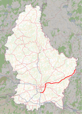
The Autoroute 1, abbreviated to A1 or otherwise known as the Trier motorway (French: Autoroute de Trèves), is a motorway in Luxembourg. It is 36.203 kilometres (22.496 mi) long and connects Luxembourg City, in the south, to Wasserbillig, in the east. A few hundred metres to the north of Wasserbillig, it reaches the German border, whereupon it becomes the A64, which leads to Trier.
| |
|---|---|
| Autobunn 1 | |
| Autoroute de Trèves | |
 | |
| Route information | |
| Part of | |
| Length | 36.203 km (22.496 mi) |
| Existed | 1969–present |
| History | Completed: 23 September 1996 |
| Major junctions | |
| Western end | Croix de Gasperich for Luxembourg City, A3, A6 |
| Kirchberg Luxembourg Airport Munsbach Mertert Wasserbillig | |
| Eastern end | Sauer Valley Bridge & Bundesautobahn 64 for Trier |
| Highway system | |
| Motorways in Luxembourg | |

Overview
Originally a connection from Luxembourg City to Luxembourg Airport, at Senningerberg, in 1969, the A1 was extended in three stages from 1988 to 1992 to connect to the German border. From 1994 to 1996, two more sections were opened, bypassing the south-east of Luxembourg City and connecting the A1 to the Croix de Gasperich, where it meets the A3 (to Dudelange) and A6 (towards Arlon, in Belgium).
In all, the A1 was opened in six separate sections:
- 1969: Kirchberg - Senningerberg
- 6 September 1988: Potaschberg - Wasserbillig
- 11 July 1990: Senningerberg - Munsbach
- 26 June 1992: Munsbach - Potaschberg
- 20 May 1994: Croix de Gasperich - Irrgarten
- 23 September 1996: Irrgarten - Kirchberg[1]
Route
| Junctions and structures | ||
| Croix de Gasperich | ||
| Howald Tunnel | ||
| Victor Bodson Bridge | ||
| Hamm / Sandweiler | ||
| Cents Tunnel | ||
| Neudorf Viaduct | ||
| Kirchberg / Grunewald Junction | ||
| Senningerberg / Airport | ||
| Cargo Centre | ||
| Munsbach | ||
| Syre Viaduct | ||
| Flaxweiler | ||
| Potaschbierg | ||
| Mertert | ||
| Wasserbillig | ||
| Wasserbillig services | ||
| Border with Germany | ||
References
- "Evolution du réseau autoroutier" (in French). Administration des Ponts et Chaussées. 24 January 2008. Archived from the original on 3 March 2009. Retrieved 29 December 2008.
External links
| Wikimedia Commons has media related to A1 (Luxembourg). |
- (in French) Administration des Ponts et Chaussées