36th Street station (SEPTA)
36th Street station is a SEPTA trolley station in Philadelphia.[2] It is located at the intersection of Sansom and 36th Streets, and serves Routes 11, 13, 34, and 36 of the SEPTA subway–surface trolley lines. Trolleys serving this station go eastbound to Center City Philadelphia and westbound to the neighborhoods of Eastwick and Angora, as well as the Delaware County suburbs of Yeadon and Darby.
36th Street | |||||||||||||||||||||||
|---|---|---|---|---|---|---|---|---|---|---|---|---|---|---|---|---|---|---|---|---|---|---|---|
 Station platform | |||||||||||||||||||||||
| Location | 36th and Sansom Streets, Philadelphia, Pennsylvania | ||||||||||||||||||||||
| Coordinates | 39.953890°N 75.194630°W | ||||||||||||||||||||||
| Owned by | Southeastern Pennsylvania Transportation Authority | ||||||||||||||||||||||
| Platforms | 2 side platforms | ||||||||||||||||||||||
| Tracks | 2 | ||||||||||||||||||||||
| Connections | SEPTA City Bus: 21 | ||||||||||||||||||||||
| Construction | |||||||||||||||||||||||
| Structure type | Underground | ||||||||||||||||||||||
| History | |||||||||||||||||||||||
| Opened | November 1955[1] | ||||||||||||||||||||||
| Electrified | Overhead lines | ||||||||||||||||||||||
| Services | |||||||||||||||||||||||
| |||||||||||||||||||||||
| Location | |||||||||||||||||||||||
 36th Street Location within Philadelphia | |||||||||||||||||||||||
The station is located adjacent to the Institute of Contemporary Art[3] and is two blocks away from the 36th Street Portal station, which serves the Route 10 trolley.
History
The station was opened in November 1955 by the Philadelphia Transportation Company (PTC) as part of a larger project to move portions of the elevated Market Street Line and surface trolleys underground.[1] The original project to bury the elevated tracks between 23rd to 46th streets was announced by the PTC's predecessor, the Philadelphia Rapid Transit Company (PRT), in the 1920s, but was delayed due to the Great Depression and World War II.[4] The PTC's revised project also included a new tunnel for trolleys underneath the campus of the University of Pennsylvania, continuing from the original western portal at 23rd and Market streets to new portals at 36th and Ludlow streets and 40th Street and Baltimore Avenue.[4]
The station is also sometimes known as Sansom Common station, referring to a former name used by the University of Pennsylvania to market retail in the area.[5][6]
Station layout
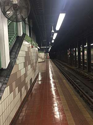
The station has two low-level side platforms, each capable of platforming two trolleys at a time. Fares are collected manually on board the trolley cars.
| G | Street level | Entrance/exit, buses |
| M | Mezzanine | Connection between platforms |
| P Platform level |
Side platform | |
| Westbound | ← Routes 11, 13, 34, 36 toward West Philadelphia (37th Street) | |
| Eastbound | Routes 11, 13, 34, 36 toward 13th Street (33rd Street) → | |
| Side platform | ||
References
- Puckett, John L. and Mark Frazier Lloyd. Becoming Penn: The Pragmatic American University, 1950-2000, p. 35, at Google Books, accessed May 31, 2020.
- Springirth, Kenneth C. (2016). Philadelphia Electrified Rail Lines In Color. Scotch Plains, New Jersey: Morning Sun Books Inc. ISBN 978-1-5824-8498-3.
- "Visit". ICA Philadelphia. Retrieved May 31, 2020.
- John L. Puckett. "Putting the Market Street Elevated Underground". West Philadelphia Collaborative History. University of Pennsylvania Graduate School of Education. Retrieved June 2, 2020.
- "Sansom Common now '36th and Walnut'". January 14, 2002. Retrieved June 2, 2020.
- "U. of Pennsylvania to build hotel and commercial hub Sansom Common, Perelman Quadrangle to change face of area". January 22, 1988. Retrieved June 2, 2020.
External links

- SEPTA – 36th Street Station (archived)
- Images at NYCSubway.org
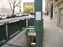
- Station entrance from Google Maps Street View