Šventoji (Neris)
The Šventoji (Lithuanian: [ɕvʲɛnˈtôːjɪ] (![]()
| Šventoji | |
|---|---|
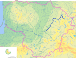 Map of the Šventoji river | |
| Location | |
| Country | Lithuania |
| Physical characteristics | |
| Source | |
| • location | Lake Samanis |
| • elevation | 225 m (738 ft) |
| Mouth | Neris |
• coordinates | 55°05′39″N 24°21′05″E |
| Length | 246 km (153 mi) |
| Basin size | 6,889 km2 (2,660 sq mi) |
| Discharge | |
| • average | 56.1 m3/s (1,980 cu ft/s) |
| Basin features | |
| Progression | Neris→ Neman→ Baltic Sea |
The Šventoji passes through the cities of Anykščiai, Kavarskas and Ukmergė. In 1963–1964 a dam near Kavarskas was built to replenish the Nevėžis using water from the Šventoji. However, the dam is no longer used as it is too expensive, ineffective, and violates environmental regulations of the European Union.[3] In 1959 the Antalieptė Reservoir, the second largest artificial lake in Lithuania, was built on the Šventoji.[2]
Tributaries
The following rivers are tributaries to the river Šventoji (from source to mouth):
- Left: Šavaša, Vyžuona, Aknysta, Taurožė, Beržuona, Elmė, Anykšta, Virinta, Dagia, Širvinta
- Right: Kriauna, Nasvė, Jara, Pelyša, Vadaksta, Grieža, Latava, Biebė
References
- "Šventosios pabaseinis" (in Lithuanian). Aplinkos apsaugos agentūra. 2009-04-27. Retrieved 2009-07-13.
- "Ten kur prasideda Šventoji..." (in Lithuanian). Gražutė Regional Park. Retrieved 2009-07-13.
- Subačius, Gintautas (2006-07-19). "Nevėžio troškulys didėja" (in Lithuanian). Sekunde.lt.
| Wikimedia Commons has media related to Šventoji. |