Červený Hrádek
Červený Hrádek (German: Rothenburg) is a village and municipality (obec) in Jindřichův Hradec District in the South Bohemian Region of the Czech Republic.
Červený Hrádek | |
|---|---|
Municipality | |
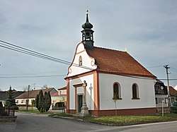 Chapel of Virgin Mary | |
 Flag  Coat of arms | |
 Červený Hrádek | |
| Coordinates: 49°7′23″N 15°32′8″E | |
| Country | |
| Region | South Bohemian |
| District | Jindřichův Hradec |
| Area | |
| • Total | 6.78 km2 (2.62 sq mi) |
| Elevation | 525 m (1,722 ft) |
| Population (2019)[1] | |
| • Total | 210 |
| • Density | 31/km2 (80/sq mi) |
| Postal code | 380 01 |
| Website | https://www.obec-cervenyhradek.cz/ |
The municipality covers an area of 6.78 square kilometres (2.62 sq mi), and has a population of 210 (as of 2019).
Červený Hrádek lies approximately 40 kilometres (25 mi) east of Jindřichův Hradec, 80 km (50 mi) east of České Budějovice, and 134 km (83 mi) south-east of Prague.
References
- "Population of municipalities of the Czech Republic". Czech Statistical Office. 1 January 2019.
This article is issued from Wikipedia. The text is licensed under Creative Commons - Attribution - Sharealike. Additional terms may apply for the media files.