Üchtelhausen
Üchtelhausen is a municipality and community in the district of Schweinfurt in Bavaria, Germany.
Üchtelhausen | |
|---|---|
.jpg) Church of Saint James | |
 Coat of arms | |
Location of Üchtelhausen within Schweinfurt district 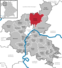 | |
 Üchtelhausen  Üchtelhausen | |
| Coordinates: 50°5′N 10°16′E | |
| Country | Germany |
| State | Bavaria |
| Admin. region | Lower Franconia |
| District | Schweinfurt |
| Subdivisions | 9 districts |
| Government | |
| • Mayor | Birgit Göbhardt (WG Zell) |
| Area | |
| • Total | 62.15 km2 (24.00 sq mi) |
| Elevation | 322 m (1,056 ft) |
| Population (2018-12-31)[1] | |
| • Total | 3,819 |
| • Density | 61/km2 (160/sq mi) |
| Time zone | CET/CEST (UTC+1/+2) |
| Postal codes | 97532 |
| Dialling codes | 09720 |
| Vehicle registration | SW |
| Website | www.uechtelhausen.de |
Geography
Üchtelhausen is located in region Main - Rhön Mountains.
It exists following districts: Ebertshausen, Hesselbach, Hoppachshof, Madenhausen, Ottenhausen, Thomashof, Weipoltshausen, Zell, Üchtelhausen.
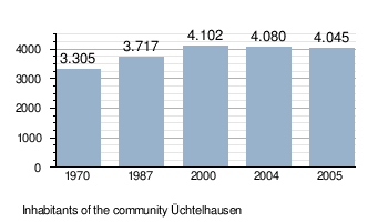
Demography
gollark: You can run it in some sort of emulator under Android, I'm sure.
gollark: There's ArchLinuxARM, but Android is a minefield of incompatible bootloaders and stuff.
gollark: His work's very, well, interesting at least.
gollark: He was insane (literally speaking) but a very good programmer.
gollark: It even has its own neat vector icon format.
References
- "Fortschreibung des Bevölkerungsstandes". Bayerisches Landesamt für Statistik und Datenverarbeitung (in German). July 2019.
| Authority control |
|
|---|
This article is issued from Wikipedia. The text is licensed under Creative Commons - Attribution - Sharealike. Additional terms may apply for the media files.