Steeles, Toronto
Steeles is a suburban neighbourhood in Toronto, Ontario, Canada. This geographically localized community is in the former municipality of Scarborough which was amalgamated into the City of Toronto in 1998. Steeles is located at the northern edge of Toronto (the very north-western corner of Scarborough) and is bordered by Steeles Avenue East to the north, Kennedy Road to the east, a hydro-electric transmission line to the south (just south of McNicoll Avenue) and Victoria Park Avenue to the west.
Steeles | |
|---|---|
Neighbourhood | |
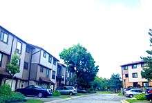
.jpg) View of southeast Steeles from L'Amoreaux Park | |
 | |
| Country | |
| Province | |
| City | |
| Population (2016)[1] | |
| • Total | 24,623 |
| • Density | 5,436/km2 (14,080/sq mi) |
Steeles lies atop the watershed of West Highland Creek. The river's source is located in L'Amoreaux Pond, behind Mary Ward Catholic Secondary School. The pond is located in the neighborhood. The parkland around this pond is some of the most scenic in the neighbourhood.
History
Archeologist Ron Williamson led a team that excavated the remains of a Huron-Wendat village near L'Amoreaux North Park Pond, which is the source of West Highland Creek. Nearly 20,000 archaeological artifacts were found in the excavation area, which was called the Alexandra site. The village is estimated to have had 1,000 inhabitants in 1400 CE.[2]
In the 17th century, the Six Nations, also known as the Iroquois, began besieging the Huron-Wendat. No longer able to resist the attacks of the Six Nations, the Huron-Wendat in the area left Southern Ontario for Quebec City in 1650.[3] European settlers settled the area following the Toronto Purchase, who converted the area into farmland which, in turn, was developed into residential, commercial, and public buildings complemented by small lots of parkland. Before the neighbourhood was developed, much of the land was covered by hardwood forests with great stands of white and red pines. However, during the 19th century, land clearing and lumbering removed most of the original forest cover.[4]
By the early 1980s, most residential development had been completed. Shepton Way was developed over the last farm in the neighbourhood in 2001.[2] Development is mostly complete in the neighbourhood, save for some new homes and businesses that continue to be built.[5]
Demographics
Major ethnic populations (2016):[1]
Economy
Small and medium-sized businesses bookend the east and west sides of the community; most commercial outlets are concentrated in the west between Victoria Park and Pharmacy. Within this commercial area, the Bank of Montreal (BMO) has a major Institute for Learning facility.[6] Bamburgh Gardens Shopping Plaza is the largest shopping centre in the neighborhood of Steeles. It can be found in the middle of the neighbourhood at 375 Bamburgh Circle, one block south of Steeles off Warden (east side). Other small and medium-sized business centres include Passmore Shoppers, and Victoria Park Business Centre.[7]
Steeles is part of the Chinatown of Scarborough, which extends into the neighbouring districts of Agincourt and Milliken.[8][9]
Education

Two public school boards operate schools in Steeles, the separate Toronto Catholic District School Board (TCDSB), and the secular Toronto District School Board (TDSB).
Both TCDSB and TDSB operate one secondary school in the neighbourhood. TCDSB operates Mary Ward Catholic Secondary School, whereas TDSB operates Dr. Norman Bethune Collegiate Institute. In addition to secondary schools, both school boards also operate several public schools in the neighbourhood. They include:
- Kennedy Public School (TDSB)[10]
- Saint Maximilian Kolbe Catholic School (TCDSB)[11]
- Sir Ernest MacMillan Senior Public School (TDSB)[10]
- Sir Samuel B. Steele Junior Public School (TDSB)[10]
- St. Henry Catholic School (TCDSB)[12]
- David Lewis Public School (TDSB)[10]
- Terry Fox Public School. (TDSB)[10]
Politics
The neighborhood of Steeles is part of the federal and provincial electoral district of Scarborough—Agincourt. Municipally, the neighbourhood is part of Ward 39.
Voter turn-out is generally lower than regional averages in elections for all three levels of government. In spite of voter apathy, Liberal candidates are very popular here as Gerry Phillips (Member of Provincial Parliament) and Jim Karygiannis (Member of Parliament) have been re-elected numerous times. Conservative candidates tend to finish second; New Democrats third; Greens fourth. Independent candidates and smaller parties run occasionally but garner few votes.
Municipal candidates tend not to run on party slates. Sherene Shaw represented Ward 39 up until she was narrowly defeated in 2003 by Mike Del Grande. Only 401 votes, or 3.3% of the vote, separated the two candidates.
Recreation
.jpg)
Steeles is home to several municipal parks that feature playgrounds, baseball diamonds, basketball courts, fitness centres, gymnasia, and playing fields for soccer, football, and cricket. Municipal parks are managed by the Toronto Parks, Forestry and Recreation Division. In addition to municipal parks, the division also manages L'Amoreaux Community Centre, located in the southeast of the neighbourhood.
Municipal parks in Steeles include:
Annual events
- Mary Ward Multimedia Exhibition. A large-scale, installation-based art and technology exhibition held every spring at Mary Ward Catholic Secondary School. Juxtapose was the inaugural show in 1998, followed by Katharsis ('99), Vertigo ('00), Incognito ('01), Manifesto ('02), Axis ('03), Ism ('04), Merge ('05), Enigma ('06), Recollect ('07), Echo ('08), Eccentrick ('09), and Tempest ('10).
- Guyana Festival. Held every summer at the L'Amoreaux Community Centre, the festival marks the anniversary of Guyana's Independence, and has earned the distinction of being the largest annual gathering of Guyanese out of Guyana.
Transportation

Roads are used by automobiles and serviced by public transit, particularly Toronto Transit Commission's (TTC) bus system. York Region Transit buses also pass through the area. Major roadways in Steeles include Victoria Park Avenue, a north-south road that acts as the neighbourhood's western boundary, Steeles Avenue, which acts as Steeles' northern boundary, Warden Avenue, a north-south road that passes through the middle of the neighbourhood, and Kennedy Road, a north-south road that acts as the neighbourhood's eastern boundary. The nearest highways are the Don Valley Parkway (404) to the west, the Express Toll Route (407) to the north, and the Macdonald-Cartier Freeway (401) to the south.
Although there are no designated bike lanes in the neighbourhood, cyclists often share the roads in addition to using the sidewalks along them and bicycle paths in parks. Such paths are also commonly used for walking and inline skating.
Notable residents
- Wesley Williams, Canadian rapper and hip hop artist known as Maestro (formerly Maestro Fresh Wes).
- Jay Manuel, make-up artist, fashion photographer, host of Canada's Next Top Model.
- Craig Kielburger, child rights advocate and author, (co-founder of Free The Children)
- Pat Mastroianni and Cassie Steele, actors (Degrassi: The Next Generation TV series)
- Amanda Walther and Sheila Carabine, singers of the band Dala
References
- "2016 Neighborhood Profile Steeles" (PDF). City of Toronto. Retrieved 9 January 2019.
- "Steeles". Toronto Community News. Retrieved 2020-08-12.
- "The Native Peoples". Wyandotte Nation. Retrieved 2020-08-12.
- ""Scarborough"". Encyclopedia Britannica. Retrieved 2020-08-12.
- Main source: "First Nations history in L'Amoreaux recognized," by Mike Adler, Scarborough Mirror, 2008.11.19.
- "About BMO IFL". BMO IFL. Retrieved 2020-08-15.
- "Steeles library | Toronto.com". Toronto Community News. Retrieved 2020-08-15.
- "Mapping "Scarborough Chinatown" | Culinaria Research Centre". www.utsc.utoronto.ca. Retrieved 2020-08-15.
- "Dragon Centre was a catalyst for Scarborough's Chinese community, but the history is not all rosy". The Star. 2019-08-21. Retrieved 2020-08-15.
- "TDSB Elementary School Listing". Toronto District School Board. Retrieved 2020-08-15.
- "Saint Maximilian Kolbe | Saint Maximilian Kolbe Catholic School". Toronto Catholic District School Board. Retrieved 2020-08-15.
- "St. Henry | St. Henry Catholic School". Toronto Catholic District School Board. Retrieved 2020-08-15.
- "Parks Listings — City of Toronto". City of Toronto. Retrieved 2020-08-15.
External links
Places adjacent to Steeles, Toronto | ||||||||||
|---|---|---|---|---|---|---|---|---|---|---|
| ||||||||||