Hurricane Charlie (1951)
Hurricane Charlie was the deadliest tropical cyclone of the 1951 Atlantic hurricane season. The third named storm, second hurricane, and second major hurricane of the season, it developed from a tropical wave east of the Lesser Antilles. It moved briskly west-northwest, passing between the islands of Dominica and Guadeloupe. It strengthened to a hurricane in the eastern Caribbean Sea, and it struck Jamaica with winds near Category 3 intensity. It strengthened to a peak intensity of 135 mph (215 km/h) prior to landfall on Quintana Roo, Yucatán Peninsula. It weakened over land, and it re-strengthened over the Gulf of Mexico before it made a final landfall near Tampico.
| Category 4 major hurricane (SSHWS/NWS) | |
_Analysis.png) Surface weather analysis of the hurricane on August 19 | |
| Formed | August 12, 1951 |
|---|---|
| Dissipated | August 23, 1951 |
| Highest winds | 1-minute sustained: 130 mph (215 km/h) |
| Lowest pressure | 958 mbar (hPa); 28.29 inHg |
| Fatalities | 252+ total |
| Damage | $75 million (1951 USD) |
| Areas affected | Lesser Antilles, Puerto Rico, Hispaniola, Jamaica, Cuba, Cayman Islands, Isle of Youth, Yucatán Peninsula, Texas |
| Part of the 1951 Atlantic hurricane season | |
In its path, Charlie caused more than 250 deaths. The hurricane produced Jamaica's deadliest natural disaster of the 20th century, causing more than 152 deaths and $50,000,000 in damages. The hurricane was described as Tampico's worst tropical cyclone since 1936, and it caused more than 100 fatalities in the surrounding areas. Many bodies were not recovered after flooding. The hurricane produced peak gusts of 160 mph (260 km/h) at the airport, and its strongest sustained winds were unmeasured in mainland Mexico, suggesting that it may have been a Category 4 hurricane at landfall.
Meteorological history
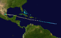
On August 12, a tropical wave organized to a tropical depression about 930 miles (1,495 km) east-southeast of the island of Barbados.[1] Operationally, the system was not detected until August 14, and it was believed to have been an area of low pressure when it moved through the eastern Caribbean.[2] It moved to the west-northwest, and it slowly organized to a minimal tropical storm on August 14.[1] Although Hurricane hunters reported winds of hurricane force in squalls, the system was discounted as an easterly wave.[2] On August 15, Tropical Storm Charlie quickly intensified, attaining maximum sustained winds of 75 mph (120 km/h) after passing through the Lesser Antilles.[1] The small center of circulation passed between Dominica and Guadeloupe in the early morning hours.[2]
On August 16, the hurricane moved steadily west-northwest 140 miles (225 km) south-southwest of San Juan, Puerto Rico.[1] Hurricane Charlie continued to strengthen, and it reached Category 2 status on August 17 as it moved quickly westward across the Caribbean Sea.[1] The cyclone intensified as it made landfall south of Kingston, Jamaica with 110 mph (175 km/h) sustained winds.[1] The city reported peak winds of 110 mph (175 km/h) as the center passed 8 miles (10 km) to the southwest, so Charlie may have been a Category 3 hurricane in Jamaica.[2] On August 18, the hurricane left the island as a Category 1 hurricane, and it quickly re-intensified over water.[1] It passed south of the Cayman Islands with 105 mph (165 km/h) sustained winds.[1] Grand Cayman reported gusts of 92 mph (150 km/h).[2] Later, it attained major hurricane status on August 19. The hurricane peaked at 135 mph (215 km/h) just before hitting near Cozumel during the night, and it weakened as it crossed the Yucatán Peninsula on August 20.[1]
Upon reaching the Gulf of Mexico, Charlie had weakened to a 105 mph (165 km/h) hurricane.[1] On August 21, it remained a Category 2 hurricane while crossing the Gulf of Mexico until 18 hours before landfall.[1] On August 22, Charlie rapidly intensified, and it strengthened to a second peak of 135 mph (215 km/h) off the mainland Mexican coast.[1] Later, Charlie made landfall near Tampico with 125 mph (200 km/h) sustained winds.[1] The strongest winds were believed to have been north of the eye, and were unrecorded.[2] The storm quickly weakened over land, and it dissipated on August 23 in the Mexican state of Tamaulipas.[1]
Preparations
On August 15, the Weather Bureau office in San Juan issued hurricane warnings for the eastern Caribbean from Martinique to Antigua, while storm warnings were released for the rest of the Leeward Islands.[3] Later, hurricane warnings were also issued for the northern Leeward Islands, and northeast storm warnings were released for Puerto Rico and the Virgin Islands.[4] In advance of the hurricane, flights' scheduled departures for the Barbados region were delayed.[5] On August 17, the Weather Bureau noted that the hurricane would affect Jamaica, though it was not expected to strengthen significantly; the agency also reported that the probabilities were equal for the cyclone to pass north or south of the island.[6] Later, the cyclone was forecast to pass "over or just south" of the island; Jamaica was urged to prepare for the cyclone, and the hurricane was expected to strengthen as the forward motion decreased.[7] On August 20, the cyclone was expected to affect the northern Yucatán Peninsula between Mérida and Campeche, and "extreme caution" was advised for the area.[8]
The hurricane was also expected to re-strengthen prior to its second landfall in Mexico, though the Weather Bureau also noted that there was a chance for the storm to affect Texas.[8] Although the possibility never materialized, the agency expected rain bands and rough seas to affect southern Texas, and small watercraft were urged to remain in ports until the hurricane moved inland.[9] On August 21, the cyclone was expected to move ashore between Nautla and Tuxpan,[9] though it eventually made landfall further north near Tampico.[1] Local officials expressed concerns about residents in huts and other vulnerable structures.[9] In the Harlingen Valley region of southern Texas, precautionary measures were taken and Red Cross divisions organized a meeting at the local city hall. City departments and facilities were ready for disposal if the cyclone moved closer to the area.[10] The cyclone's rains were also expected to impact unpicked cotton plants in the region.[11] In advance of the storm, a Coast Guard plane dropped messages from the air to several vessels, advising them to seek shelter.[10] In Tampico, oil industries erected barriers to protect fields, and authorities planned to evacuate residents from the surrounding low-lying areas. Thousands of residents stayed in refugee centers on elevated ground.[11]
Impact
The cyclone was compact when it moved through the Lesser Antilles, and the strongest winds on land in the eastern Caribbean islands did not exceed 35 mph (55 km/h).[2] In Jamaica, the hurricane produced heavy rainfall, peaking at 17 inches (430 mm) in Kingston,[2][12] which caused numerous landslides across eastern sections of the island.[13] Peak gusts were estimated near 125 mph (200 km/h) across the island.[14] A hangar and installations were destroyed at Palisadoes Airport,[12] and the facility received "extensive damage."[14] Consequently, "At Memphis, Tenn, Chicago & Southern Airline headquarters here reported that its north and southbound Constellation flights were unable to land at Kingston, bypassing the airport there on flights between Chicago and Caracas."[14] Several ships were sunk or overturned during the storm.[12][14] Communications and power services were disrupted, suspending information from the island's interior.[12] The hurricane also cut communications from the island to radio stations in the United States.[14] 70–80 percent of the island's banana crops were destroyed, in addition to 30 percent of other crops.[9] 70 convicted felons also escaped from a jail when winds blew down walls.[15] Flooding was expected in the island's mountainous interior because of heavy precipitation.[12] Heavy rains caused rock slides, damaging roads, railroads, and other sources of tourism.[9] In Kingston, electricity was initially restored to essential services, including "hospitals, refrigerating plants, pumping stations and newspaper plants."[9] Charlie caused around $50 million (1951 USD, $380 million 2005 USD) in crop and property damage, 152 deaths, injured 2,000, and left 25,000 homeless.[2]
On the Yucatán Peninsula, Charlie destroyed up to 70% of the crops, though no loss of life was reported in the area.[2] Unofficially, one person was reportedly killed on the peninsula.[9] Mérida reported winds of 70 mph (110 km/h).[9] The winds toppled several thatched homes on Cozumel.[10] A wind gust of 160 mph (260 km/h) was measured at the airport near Tampico,[16] though peak gusts in the city did not exceed 110 mph (175 km/h).[2] The storm was reported to be the worst in Tampico since 1936. The winds uprooted trees and destroyed telephone poles, and damages to corn crops were believed to exceed $500,000.[16] At least 300 residences were "damaged or destroyed."[16] Outside the city, Charlie's heavy rain led to bursting dams and flooded rivers, where upward of 100 people died.[2] In the city, four people died, and property losses were estimated near $1,160,000.[2]
The hurricane's outer fringes produced swells along the Texas coast, and swimmers were advised to be cautious because of hazardous conditions.[15] The area was also experiencing rough swells and strong winds from an unrelated weather system, which produced peak gusts of 60 mph (95 km/h).[15] The conditions snarled marine operations in the area, and three fishermen were missing during the squall.[15] On August 23, Brownsville experienced gusts of 50 mph (80 km/h) when the hurricane struck the coast further south.[16]
Aftermath
In the wake of this storm, Jamaica formed a new governmental entity known as the Hurricane Housing Organization. In 1956, this organization merged with the Central Housing Authority to become the Department of Housing.[17]
References in Popular Culture
Lord Beginner wrote a calypso song about the hurricane's landfall in Jamaica entitled "Jamaica Hurricane".
See also
- Hurricane Allen (1980)
- Hurricane Gilbert (1988)
- Hurricane Emily (2005)
- Hurricane Dean (2007)
- List of Atlantic hurricanes
References
- "Atlantic hurricane best track (HURDAT version 2)" (Database). United States National Hurricane Center. May 25, 2020.
- Norton, Grady (1952). "Hurricanes of 1951" (PDF). U.S. Weather Bureau. Archived from the original (PDF) on 2011-05-25. Retrieved 2008-02-08.
- United Press (1951). "Hurricane Reported in Atlantic". The Corpus Christi Times. Missing or empty
|url=(help) - United Press (1951). "Howler 'Sags,' Expected to Pick Up Again". The Galveston Daily News. Missing or empty
|url=(help) - The Daily Gleaner (1951). "Hurricane in the Caribbean: Planes Held Up". Missing or empty
|url=(help) - The Daily Gleaner (1951). "Hurricane May Hit Jamaica Today". Missing or empty
|url=(help) - The Associated Press (1951). "Rising Tropical Storm Heading Toward Jamaica". Panama City News-Herald. Missing or empty
|url=(help) - International News Service (1951). "Killer Hurricane Batters the Yucatan Peninsula". The Lowell Sun. Missing or empty
|url=(help) - United Press (1951). "130 MPH Hurricane Heads for Tampico; 115 Dead". The Daily Review. Missing or empty
|url=(help) - Valley Morning Star (1951). "Hurricane "Charlie" Heads Towards Mexico". Missing or empty
|url=(help) - The Associated Press (1951). "Tampico Girds for Hurricane". The Abilene Reporter-News. Missing or empty
|url=(help) - The Associated Press (1951). "25 Dead, Severe Property Damage in Jamaica Storm". Big Spring Daily Herald. Missing or empty
|url=(help) - Ahmad, Rafi, Lawrence Brown, Jamaica National Meteorological Service (2006-01-10). "Assessment of Rainfall Characteristics and Landslide Hazards in Jamaica" (PDF). University of Wisconsin. p. 27. Archived from the original (PDF) on 2016-03-04. Retrieved 2012-06-06.CS1 maint: multiple names: authors list (link)
- United Press (1951). "Tropic Hurricane Batters Jamaica". Nevada State Journal. Missing or empty
|url=(help) - The Galveston Daily News (1951). "Rain Cuts Heat Wave". Missing or empty
|url=(help) - The Associated Press (1951). "160-Mile Winds Batter Tampico; Damage Heavy". The Abilene Reporter-News. Missing or empty
|url=(help) - Reuters (1969). "It's time (June) to match for Anna..." The Daily Gleaner. Retrieved on 2009-01-04.
